Auburn State Recreation Area
Also known as Auburn SRA
- Status
- Open (per official listing)Daily sunrise – sunset
- Entrance fee
- $10 per dayAnnual pass available
- Day-use reservations
- None mentioned
- Dogs
- Dogs allowed6-ft leash
- Camping
- Yes
- Official site
- parks.ca.gov(530) 885-4527
Official page last checked Oct 29, 2026. How we keep this current
Overview
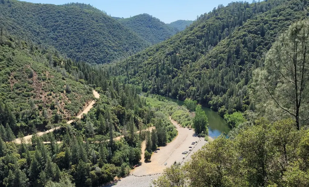

Covering about 30,382 acres, Auburn State Recreation Area lies in El Dorado County, about 2 miles northeast of Auburn.
The park supports off-highway vehicle riding, horseback riding, historic sites, boating, and swimming. Facilities for water recreation include a swimming beach. Overnight options include campsites, with tent sites.
Hours
Park, gate, office and facility hours are listed separately because they often differ. Alerts above override normal hours.
| Facility | Days | Hours | Season |
|---|---|---|---|
| Day use | Daily | sunrise – sunset | — |
| Office | Daily | 8 a.m. – 4 p.m. | — |
| Park | Daily | 8 a.m. – sunset | — |
| Other — Upper Lake Celementine | Daily | 8 a.m. – 6:30 p.m. | — |
| Other — Seasonal Access | Daily | 8 a.m. – sunset | — |
Official wording
Day Use: Sunrise to Sunset
Auburn Sector Office: 8am to 4pm, open daily excluding holidays
Mammoth Bar, China Bar, Lower Lake Clementine: 8am to Sunset
Upper Lake Celementine: 8am to 6:30pm
Seasonal Access: Upper Lake Clementine - Reservations required on weekends during peak season from Memorial Day Weedend to Labor Day Weekend. Due to the ongoing, unsafe traffic conditions on Foresthill Road, Upper Lake Clementine will be transitioning to day use vehicle reservations 7 days a week during peak season. Reservations are required on Weekends and highly recommended on Weekdays. Weekdays still allow first come, first served, but are limited to the number of remaining parking spots and can be turned away. Weekend visitors without a reservation will not be admitted into the park. Park visitors with a reservation are guaranteed a parking spot and may arrive at any time in the day. Reservations can be made 10 days prior to your desired date at 8:00am (subtract 10 days from the desired date) and must be made 2 days prior. For reservations click here: LAZ Reservations (lazparking.com). If you attempt to make a reservation and receive the following notification, the date requested is sold out: Online reservations are not available at this location for the date and time you selected. Please try searching for another date and time. Upper Lake Clementine is subject to closure due to poor weather, or routine maintenance. Lower Lake Clementine Boat-In Campground - OPEN. - Reservations required when open Make a Reservation Ruck-A-Chucky Campground/Driver's Flat Road - OPEN. Mineral Bar Campground - Six sites first come, first served 10/15/25-4/30/26. All fifteen sites open on 4/15/26) - Reservations required when fully open 5/15/26 Make a Reservation China Bar - Open to vehicle access 7 days a week from 8am until sunset. Cherokee Bar/ Sliger Mine Rd. - OPEN.
Seasons/Climate/Recommended Clothing: Summer temperatures here average from high~80s to mid~90s, and winters are wet, with highs in the mid~50s and lows in 30s and low~40s. Dress in layers, and bring rain gear between October and April.
Source: official park page, checked Oct 29, 2026. Times are local to the park (America/Los Angeles).
Fees and passes
| Item | Amount |
|---|---|
| Vehicle Day Use | $10 |
Official wording
Special rates may apply for peak season, high demand holiday periods, and during weekends. Prices are subject to change without notice. • Vehicle Day Use: $10.00
California park passes
- California Explorer Annual Pass — $195. Vehicle day-use entry to 134 state parks incl. high-demand Southern California beaches Details
- Golden Poppy Annual Pass — $125. Vehicle day-use entry to 112 state parks Details
- Historian Passport — $50. Admission for up to four people at per-person-fee State Historic Parks Details
- Off-Highway Vehicle (OHV) Annual Pass — $50. Entry to State Vehicular Recreation Areas that collect day-use fees Details
- SNO-Park Pass — $40 season / $15 day. 18 SNO-PARK winter recreation areas Details
From the California state guide. Confirm which passes this park accepts.
Reservations
- Day use
- No day-use reservation requirement mentioned
- Camping
- Not required
- Booking system
- ReserveCalifornia
- Phone
- (800) 444-7275
Mineral Bar Campground - Six sites first come, first served 10/15/25-4/30/26.
We link to the official booking system rather than showing live availability, which changes minute to minute.
Pets
Dogs allowed · leash up to 6 feet
Are dogs allowed? Yes: Dogs allowed, with the exception of Lake Clementine, where no dogs are allowed. Mutt Mitts are availble at various locations to help pick up after your dog. • Pets must be under control and on a leash no longer than six feet.
Service animals are generally permitted where pets are not. Check with the park for specific areas.
Camping
Lower Lake Clementine Boat-In Campground - OPEN. - Reservations required when open Make a Reservation
Ruck-A-Chucky Campground/Driver's Flat Road - OPEN.
Mineral Bar Campground - Six sites first come, first served 10/15/25-4/30/26. All fifteen sites open on 4/15/26) - Reservations required when fully open 5/15/26 Make a Reservation
Major recreational uses include hiking, river access, boating, fishing, camping, mountain biking, gold panning, limited hunting, equestrian/horseback riding trails and off-highway motorcycle riding. Whitewater recreation is also very popular on both forks of the river, with Class II, III, IV, and V runs. Over 30 -private outfitters are licensed to offer whitewater trips in Auburn SRA.
Overnight facilities: Tent Camping, Remote Camping, Boat-in/Floating Camps
From the official park page, checked Oct 29, 2026. Site counts and prices can change; confirm when booking.
Things to do
BoatingHistoric sites and toursPicnickingFishingRanger and interpretive programsOff-highway vehiclesSwimmingHikingHorseback ridingCamping
Amenities
Facilities
- Restrooms
- Picnic areas
- Nature center or museum
- Parking
Water
- Swimming beach
Camping
- Tent camping
Recreation
- Horse trails
✓ listed by the park · ✕ the park says it is not available. Anything not shown here isn’t mentioned by the official source — that means unknown, not unavailable.
Accessibility
Overview
In the heart of the gold country, Auburn State Recreation Area covers 40-miles of the North and Middle Forks of the American river. Once teeming with thousands of gold miners, the area is now a natural area offering a wide variety of recreation opportunities to over 900,000 visitors a year. Phone (530) 885-4527 for more information.
Trails
The Quarry Trail is an ‘out-and-back’ accessible trail that is 1.3 miles each way along the bank of the Middle Fork of the American River. The trail starts at a parking lot on the east side of Highway 49, south of the intersection of Highway 49 and Old Foresthill Road. The trail is constructed of compacted aggregate that is usable year-round, and offers great views of the river along its length. The accessible portion of the trail ends at a large staging area that has accessible picnic tables and shade cabanas. The trail is generally flat at less than 5% slopes with intermittent sections between 5% to 8%. The trail descends from the parking lot and maybe more challenging uphill hike back especially the last 0.07 miles. Accessible parking is available at the trailhead. Accessible restrooms are located at located at the end of the accessible trail and at the 0.30 mile and 0.07 mile markers.
Read more from the park
Trail Name Running Slope Cross Slope Trail Width Trail Surface
Quarry Trail 3% Average 2.3% Average 9 FT Average Aggregate
8% Maximum 5% Maximum 5 FT Minimum
Other Information
Mineral Bar Area: Restrooms, including parking, in the picnic area as well as at the raft put in area are accessible.
Official accessibility information
Conditions change. Contact the park to confirm specific accessible features before your visit.
Rules and permits
Gold Panning Regulations
The Auburn SRA allows gold panning using the “hands and pans” method. Please abide by the following regulations when collecting minerals:
Panning for gold is considered to be “rockhounding” as the term is applied in the Department. The goldpan is the only exception permitted to the exclusion of tools from rockhounding in a unit (T-14 CCR 4611 (i))
Rockhounding is the recreational gathering of stones and minerals found occurring naturally on the undisturbed surface of the land, including panning for gold in the natural water-washed gravel beds of streams (T-14 CCR 4301(v)).
Tools and equipment may not be used in rockhounding, except gold pans. Rocks or minerals gathered may not be sold or used commercially for the production of profit. One person may gather no more than 15 pounds of mineral material per day. Historic and prehistoric or archeological specimens may not be gathered. In state recreation areas rockhounding is limited to beaches which lie within the jurisdiction of the Department and within the wave action zone on lakes, bays, reservoirs, or on the ocean, and to the beaches or gravel bars which are subject to annual flooding on streams. Rockhounding is limited to within the wave action zones of lakes and streams. Muddy water from panning must not be visible more than 20 feet from the panning operation (T-14 CCR 4307, 4308, & 4611).
Read more from the park
If you have any questions, please call the Auburn SRA office for more information.
Getting there
- Address
- Forest Hill Road
Auburn, CA 95603 - Nearest town
- Auburn — about 2 mi northeast (straight line)
- Coordinates
- 38.9158, -121.0410
- Phone
- (530) 885-4527
Entrances
- Directions point
Google Maps directionsApple MapsOfficial park map (PDF)
Directions from the park
The park (which is 20 miles long on two forks of the American River) is situated south of Interstate 80, stretching from Auburn to Colfax. The main access is from Auburn, either on Highway 49 or the Auburn-Foresthill Road.
Nearby state parks
Sources and freshness
- California State Parks — park page — last checked Oct 29, 2026
- California State Parks Listing page (one link per unit, page_id = officialId), unioned with the CSP Enterprise GIS 'ParkEntryPoints' ArcGIS layer (coords, address, county, unit number, management status) and the 'CSPParkUnit_CurrentStatus' layer (open/partial/full closure)
- Wikidata
- USGS PAD-US 4.1 (boundary and acreage)
- Photo: Auburn State Recreation Area (51341793484).jpg — Public domain (US federal government work), blmcalifornia
“Last checked” is when our system last read the official source. No change has been detected since this page was first published. Hours, fees and rules can change without notice — confirm with the park before you go. Methodology