Raccoon Creek State Park
- Status
- Open (per official listing)Daily sunrise – sunset
- Entrance fee
- Not posted
- Day-use reservations
- None mentioned
- Dogs
- Dogs allowed
- Camping
- 177 campsitesAlso cabins
- Official site
- pa.gov(724) 899-2200
Official page last checked Oct 29, 2026. Details last changed Oct 29, 2026. How we keep this current
Current alerts 2
Alert Prevent tick bites! • Wear repellent • Check for ticks daily • Shower soon afPrevent tick bites! • Wear repellent • Check for ticks daily • Shower soon after being outdoors • Call your doctor if you get a fever or rash… (more)
Prevent tick bites! • Wear repellent • Check for ticks daily • Shower soon after being outdoors • Call your doctor if you get a fever or rash For more information: www.cdc.gov/ticks
Posted by the park. Official alert
Alert PLEASE DON'T PICK WILDFLOWERSThe picking of any wildflower is illegal and can result in legal action. Please help us to conserve the natural beauty of our park by not picking… (more)
The picking of any wildflower is illegal and can result in legal action. Please help us to conserve the natural beauty of our park by not picking wildflowers at Raccoon Creek State Park, especially in our Wildflower Reserve. Thank you!
Posted by the park. Official alert
Overview
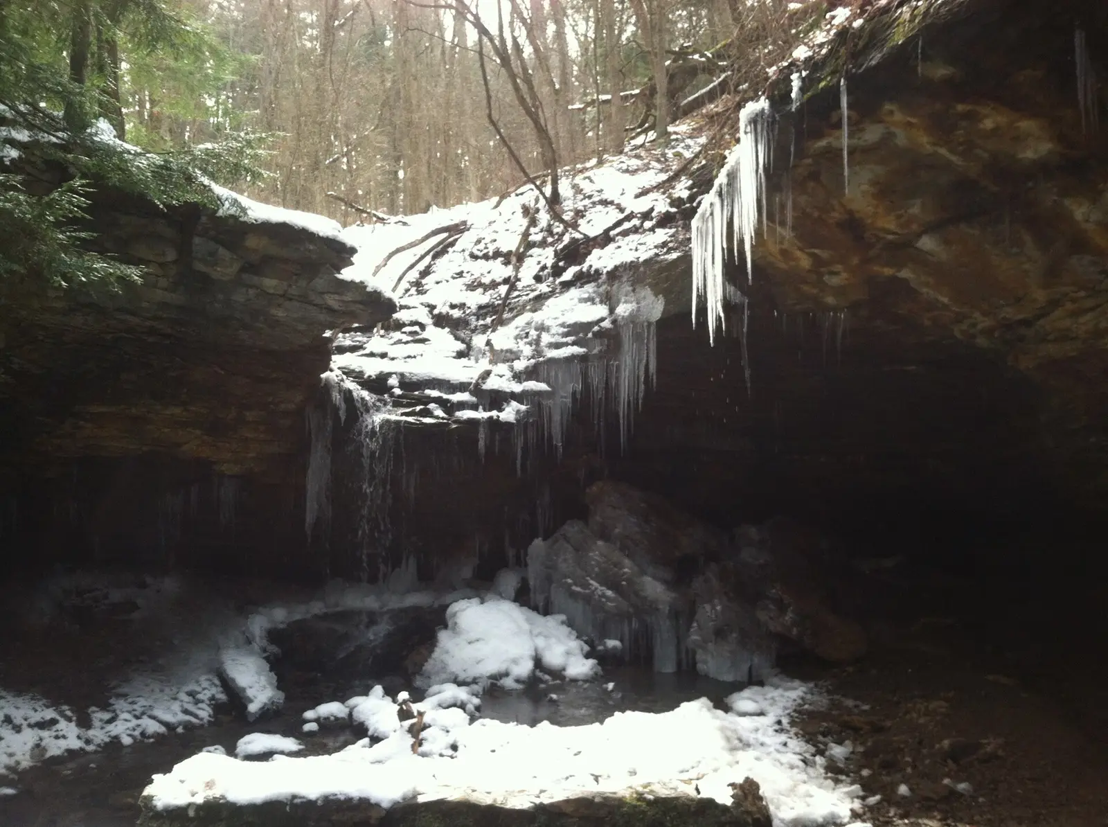

Raccoon Creek State Park is a 7,433-acre park in Beaver County, about 10 miles northeast of Weirton.
Visitors come for snorkeling and diving, snowmobiling, cross-country skiing, mountain biking, and horseback riding. Facilities for water recreation include a swimming beach, a boat ramp, a fishing pier, and boat or kayak rentals. For overnight stays there are 177 campsites across 6 camping areas (RV sites, tent sites, primitive or hike-in sites, group camping, and showers). There are also cabins for rent.
Hours
Park, gate, office and facility hours are listed separately because they often differ. Alerts above override normal hours.
| Facility | Days | Hours | Season |
|---|---|---|---|
| Park | Daily | sunrise – sunset | — |
Official wording
The park is open every day of the year, sunrise to sunset. Day use areas close at dusk. The park office is open specific hours. The beach, overnight areas, and other areas are open specific seasons and hours. Contact the park office for facility seasons and hours.
Source: official park page, checked Oct 29, 2026. Times are local to the park (America/New York).
Reservations
- Day use
- No day-use reservation requirement mentioned
- Booking system
- ReserveAmerica (Aspira), Pennsylvania State Parks contract
- Phone
- 888-PA-PARKS (888-727-2757)
We link to the official booking system rather than showing live availability, which changes minute to minute.
Pets
Dogs allowed
Pets are permitted in C and F campsite loops. Pets are permitted. Pets are prohibited. Sioux is open year round and pets are permitted. Pioneer areas are open from mid-April to the end of November and pets are prohibited.
Service animals are generally permitted where pets are not. Check with the park for specific areas.
Camping
| Campground or site type | Sites | Hookups / features | Price |
|---|---|---|---|
| Camping -- Modern Sites Season: • E and F loops open early April and close in mid-October. • A, B, C, and D loops open late May and close mid-September Raccoon Creek State Park Campground Map (PDF)
♿ The 172 modern tent and trailer campsites have access to flush facilities, warm showers, and the option of electricity. Each site also has a picnic table and fire ring. Pets are permitted in C and F campsite loops.
Sites B1, B2, B3, C38, E2, E3, F21, and F23 are ADA accessible.
The wooded campground offers:
• Selection of secluded or adjoining sites
• Playground
• Five central washhouses
• Sanitary dump station
Camping seasons:
• E and F loops open early April and close in mid-October.
• A, B, C, and D loops open late May and close mid-September | 172 | ♿ The 172 modern tent and trailer campsites have access to flush facilities, warm showers, and the option of electricity.Showers | — |
| Camping -- Rustic Sites Season: Sioux Rustic Campground is open year round. Sioux Rustic Campground is open year round. Potable water and non-flush toilets are available. Pets are permitted.
Access is not guaranteed during severe winter storms. | — | — | |
| Backpacking 19.5 miles
The Pioneer and Sioux backpacking areas both offer five Adirondack shelters and five tenting sites. These shelter and tent sites are for backpacking only and can be reserved through the park office or online under “Permits and Wilderness.”
The Heritage, Forest, and Appaloosa trails make up the green-blazed Raccoon Loop Backpacking Trail, the longest loop trail in the park. | 5 | — | |
| Organized Group Tenting Season: Sioux is open year round and pets are permitted. Pioneer areas are open from mid-April to the end of November and pets are prohibited. There are six group tenting areas in the western side of the park.
Sioux A and Sioux B are located within the Sioux Rustic Campground and accommodate 20 and 60 people respectively. Sioux is open year round and pets are permitted.
The more remote Pioneer area is divided into four group tenting sites:
• Apache -- 60 people
• Blackfeet -- 20 people
• Cherokee -- 60 people
• Mohawk -- 40 people
Pioneer areas are open from mid-April to the end of November and pets are prohibited. | — | — | |
| Organized Group Cabin Camps These three camps are rented from mid-April (earliest) to mid-October (latest), for a nominal fee to nonprofit, organized, adult and youth groups like scout, YMCA, school, church, or other organizations.
The camps contain rustic lodges, flush toilets, shower houses, dining halls, cabins, and utility buildings:
• Camp #1 holds 30 campers
• Camp #2 holds 130 campers
• Camp #3 holds 80 campers
Call the park office to make a reservation. Seasonal availability varies. | — | • Camp #1 holds 30 campers • Camp #2 holds 130 campers • Camp #3 holds 80 campersShowers | — |
| Maps and rosters for the group cabin camps Camp #1 Organized Group Cabin Camp Map and Roster (DOC)
Camp #2 Organized Group Cabin Camp Map (PDF)
Camp #2 Organized Group Cabin Camp Roster (DOC)
Camp #3 Organized Group Cabin Camp Map (PDF)
Camp #3 Organized Group Cabin Camp Roster (DOC) | — | Camp #1 Organized Group Cabin Camp Map and Roster (DOC) Camp #2 Organized Group Cabin Camp Map (PDF) Camp #2 Organized Group Cabin Camp Roster (DOC) Camp #3 Organized Group Cabin Camp Map (PDF) Camp #3 Organized Group Cabin Camp Roster (DOC) | — |
Camping details from the park
Camping -- Modern Sites
Raccoon Creek State Park Campground Map (PDF)
♿ The 172 modern tent and trailer campsites have access to flush facilities, warm showers, and the option of electricity. Each site also has a picnic table and fire ring. Pets are permitted in C and F campsite loops.
Sites B1, B2, B3, C38, E2, E3, F21, and F23 are ADA accessible.
The wooded campground offers:
- Selection of secluded or adjoining sites
- Playground
- Five central washhouses
- Sanitary dump station
Camping seasons:
- E and F loops open early April and close in mid-October.
- A, B, C, and D loops open late May and close mid-September
Camping -- Rustic Sites
Sioux Rustic Campground is open year round. Potable water and non-flush toilets are available. Pets are permitted.
Access is not guaranteed during severe winter storms.
Backpacking
19.5 miles
The Pioneer and Sioux backpacking areas both offer five Adirondack shelters and five tenting sites. These shelter and tent sites are for backpacking only and can be reserved through the park office or online under “Permits and Wilderness.”
The Heritage, Forest, and Appaloosa trails make up the green-blazed Raccoon Loop Backpacking Trail, the longest loop trail in the park.
Organized Group Tenting
There are six group tenting areas in the western side of the park.
Sioux A and Sioux B are located within the Sioux Rustic Campground and accommodate 20 and 60 people respectively. Sioux is open year round and pets are permitted.
The more remote Pioneer area is divided into four group tenting sites:
- Apache -- 60 people
- Blackfeet -- 20 people
- Cherokee -- 60 people
- Mohawk -- 40 people
Pioneer areas are open from mid-April to the end of November and pets are prohibited.
Organized Group Cabin Camps
These three camps are rented from mid-April (earliest) to mid-October (latest), for a nominal fee to nonprofit, organized, adult and youth groups like scout, YMCA, school, church, or other organizations.
The camps contain rustic lodges, flush toilets, shower houses, dining halls, cabins, and utility buildings:
- Camp #1 holds 30 campers
- Camp #2 holds 130 campers
- Camp #3 holds 80 campers
Call the park office to make a reservation. Seasonal availability varies.
Maps and rosters for the group cabin camps
Camp #1 Organized Group Cabin Camp Map and Roster (DOC)
Camp #2 Organized Group Cabin Camp Map (PDF)
Camp #2 Organized Group Cabin Camp Roster (DOC)
Camp #3 Organized Group Cabin Camp Map (PDF)
Camp #3 Organized Group Cabin Camp Roster (DOC)
From the official park page, checked Oct 29, 2026. Site counts and prices can change; confirm when booking.
Cabins and lodging
- Modern Cabins: 10 units
- Lakeside Lodge
Modern Cabins
Raccoon Creek State Park Cabin Map (PDF)
♿ Cabin #10 is ADA accessible.
The 10 modern cabins contain:
- Furnished living area
- Kitchen/dining area
- Full bathroom
- Two or three bedrooms that sleep six or eight people
The cabins have electric heat and are available for rent year round. Cabins 1-4 and 8-10 accommodate six guests. Cabins 5-7 accommodate eight guests.
Cabin users must bring their own cooking and eating utensils and bed and bath linens.
Pets are prohibited.
Cabins have a two-night minimum and a 14-night maximum stay in the non-peak season. In the summer peak season, the second Friday in June to the third Friday in August, rentals are weekly, Friday to Friday.
Lakeside Lodge
This three-bedroom cottage sleeps 10 people. The lodge has:
Read more from the park
- Full kitchen with cookware and table ware
- Dining room
- One and one-half bathrooms
- Living room with a fireplace
- Laundry facilities
- Central heat and air conditioning
- Large patio area with an outdoor gas grill
Pets are prohibited.
Alcoholic beverages are permitted in this overnight facility and associated curtilage only. Alcohol possession and consumption is restricted to the holder of the reservation permit and invited guests age 21 and older. Responsible and legal alcohol consumption is required, and violations are grounds for removal from the state park without refund.
Note that alcohol possession and consumption in all other overnight facilities and all other areas of state parks is prohibited.
Items the renters need to bring with them are:
- Bed linens
- Pillows
- Blankets
- Towels
- Dish soap
- Laundry detergent
- First aid kit
Optional items to consider bringing are:
- Bow saw
- Matches
- Lawn chairs
- Cell phone
- TV w/antenna
- Radio
Lakeside Lodge has a two-night minimum and a 14-night maximum stay in the non-peak season. In the summer peak season, the second Friday in June to the third Friday in August, rentals are weekly, Friday to Friday.
Things to do
Winter sportsSnowmobilingHikingBikingMountain bikingSnorkeling and scubaHuntingBoatingFishingSwimmingCross-country skiingHorseback ridingPicnickingCampingCanoeing and kayaking
Trails
| Trail | Length | Difficulty | Notes |
|---|---|---|---|
| Appaloosa Trail | 3 mi | More difficult | Recreations permitted: hiking, backpacking, mountain biking, equestrian Trailhead amenities: picnic tables The trail winds along rolling forested hills and passes an old homestead and spring house. Connector trails lead to the Pioneer Group Tenting Area and backpacking campsites.HikingBackpackingMountain bikingEquestrian |
| Appaloosa Spur Trail | 0.7 mi | Easiest | Recreations permitted: hiking, backpacking, mountain biking, equestrian Trailhead amenities: none This trail connects the equestrian trailhead parking lot to the Appaloosa Trail.HikingBackpackingMountain bikingEquestrian |
| Beach Trail | 0.3 mi | Most difficult | Recreations permitted: hiking Trailhead amenities: modern restrooms, potable water, picnic tables, benches This steep trail connects the D Loop of the campground to the beach and swimming area of Raccoon Lake.Hiking |
| Buckskin Trail | 1 mi | More difficult | Recreations permitted: hiking, mountain biking, equestrian Trailhead amenities: none This loop trail begins and ends on Nichol Road and winds through a mixed forest of evergreens and deciduous trees.HikingMountain bikingEquestrian |
| Camp Trail | 1.5 mi | More difficult | Recreations permitted: hiking Trailhead amenities: none A favorite trail for wildlife and waterfowl viewing along the parks upper lake and wetlands. The trail ends at the intersection with Pinto Loop Trail.Hiking |
| Cross-country Ski Trail | 2.1 mi | Easiest | Recreations permitted: hiking, cross-country skiing recommended Trailhead amenities: none This trail travels through pine forest and small meadows.HikingCross-country skiing recommended |
| Forest Trail | 6.2 mi | More difficult | Recreations permitted: hiking, backpacking Trailhead amenities: none Trail transects several stream valleys that feed Raccoon Lake and passes through an old stone quarry and homestead sites. High ridges offer scenic views of the Lake and valleys. Diverse tree species create an exceptional fall foliage display.HikingBackpacking |
| Heritage Trail | 9.5 mi | Most difficult | Recreations permitted: hiking, backpacking Trailhead amenities: none The longest trail in the park, Heritage Trail passes through the property and old homesteads of the first settlers to the area. Sections of the trail follow old wagon roads, the historic Frankfort Mineral Springs, and evergreen tree plantations planted by the Civilian Conservation Corps in the 1930's.HikingBackpacking |
| Heron Trail | 0.5 mi | More difficult | Recreations permitted: hiking Trailhead amenities: none This short trail connects Wetlands Trail to Nichol Road by the intersection with Palomino Trail. At the junction with Wetland Trail, look for waterfowl and other wetland animals near Upper Lake.Hiking |
| Lake Trail | 1.9 mi | More difficult | Recreations permitted: hiking Trailhead amenities: none The trail follows an old road along Traverse Creek which leads to Raccoon Lake on the North Shore opposite the beach area. During the 1800's a gristmill, stone spring house and several homesteads were along Traverse Creek and the Trail.Hiking |
| Mineral Springs Loop Trail | 1.2 mi | Easiest | Recreations permitted: hiking Trailhead amenities: none The trail passes through one of the parks historical areas once known for the healing qualities of its mineral water. Remnants of the 1800's Frankfort Mineral Springs Resort are located above the springs and waterfall area.Hiking |
| Nichol Road | 3.5 mi | More difficult | Recreations permitted: hiking Trailhead amenities: picnic tables This trail serves as the gateway to most of trails in the western section of the park. The section from Doak Field to Pioneer Road is considered a trail since it is rougher than the road sections. Several loops of varying lengths can be created using Nichol Road and connecting Trails.Hiking |
| Palomino Trail | 1.1 mi | Easiest | Recreations permitted: hiking, mountain biking, equestrian Trailhead amenities: none This trail follows an old roadbed. It begins and ends on Nichol Road.HikingMountain bikingEquestrian |
| Pinto Loop Trail | 1.7 mi | Easiest | Recreations permitted: hiking, mountain biking, equestrian, cross-country skiing recommended Trailhead amenities: none This wide trails has sections that follow an old wagon road through small forest meadows.HikingMountain bikingEquestrianCross-country skiing recommended |
| Upland Trail | 0.6 mi | More difficult | Recreations permitted: hiking Trailhead amenities: none This short trail begins across from the park office and connects to the Mineral Springs Loop Trail.Hiking |
| Valley Trail | 1.1 mi | More difficult | Recreations permitted: hiking Trailhead amenities: none Cut in along a steep section of Traverse Valley, the trail passes through an open hardwood forest and ends at the Beach Trail above the Raccoon Lake beach area and below the Campground.Hiking |
| Wetlands Trail | 1.2 mi | More difficult | Recreations permitted: hiking Trailhead amenities: none This trail follows the north shore of the Upper Lake and wetlands area then cuts up the ridge paralleling the Traverse Valley. The wetland habitat along the trail is one of the best areas in the park for observing wildlife like beaver, muskrats, turtles, waterfowl and songbirds. The trail connects to Nichol Road and Cabin Road which can be used to create a loop hike.Hiking |
| Art Witt Trail | 0.26 mi | Easiest | Recreations permitted: hiking Trailhead amenities: none This short, fern-lined trail meanders through a pine forest at the entrance of the Wildflower Reserve. This trail is dedicated to Art Witt, the first person to complete 10,000 volunteer hours in Pennsylvania state parks.Hiking |
| Audubon Trail | 0.44 mi | More difficult | Recreations permitted: hiking Trailhead amenities: none Audubon Trail is elevated high above the flowing waters of Raccoon Creek, with many spots to stop and admire the valley below. During spring, this is a good trail for birding and in autumn it is great for fall foliage. One end of the trail intersects Max Henrici, Jennings, and Old Field trails.Hiking |
| Beaver Trail | 0.22 mi | Easiest | Recreations permitted: hiking Trailhead amenities: none Beaver Trail passes through an American sycamore forest along the banks of Raccoon Creek with several nice areas to view wildlife.Hiking |
| Esther Allen Trail | 0.12 mi | Easiest | Recreations permitted: hiking Trailhead amenities: none This short trail connects Old Wagon Road with Jennings Trail. It honors Esther Allen for her volunteer work in educating park visitors about the botanical treasures of the Wildflower Reserve.Hiking |
| Hickory Trail | 0.16 mi | Easiest | Recreations permitted: hiking Trailhead amenities: none Much of this trail follows along the bank of Raccoon Creek. There is a very short trail spur that leads to a scenic spot along the creek. This trail honors the Hickory Club, an outdoor association, which preserved a large section of the present-day Wildflower Reserve.Hiking |
| Jennings Trail | 1.54 mi | More difficult | Recreations permitted: hiking Trailhead amenities: picnic tables This is the longest trail in the Wildflower Reserve. It travels past the historic Hungerford Cabin, vernal pools, forested banks along Raccoon Creek, spectacular diversity of wildflowers, fall foliage, and many locations for wildlife and birding observations. The trail honors botanist, O. E. Jennings, for his contributions to the Wildflower Reserve.Hiking |
| Max Henrici Trail | 0.51 mi | More difficult | Recreations permitted: hiking Trailhead amenities: none This trail allows hikers to explore a forested valley of the reserve featuring an abundance of ferns. The eastern section is covered by wildflowers in the spring. This trail honors Max Henrici, who strongly advocated the preservation of the reserve and played a leading role in the development of the trail system in the Wildflower Reserve.Hiking |
| Meadow Trail | 0.36 mi | Easiest | Recreations permitted: hiking Trailhead amenities: none This trail begins and ends in a hardwood forest with a large meadow in the middle. In August and September, the meadow is filled with late summer wildflowers. It is also a great location for watching butterflies and hummingbird moths.Hiking |
| Old Field Trail | 0.65 mi | Easiest | Recreations permitted: hiking Trailhead amenities: none This trail traverses an old field undergoing forest succession and has several sections that follow the banks of Raccoon Creek. Old Field Trail connects with Max Henrici Trail on both ends.Hiking |
| Old Wagon Road | 0.19 mi | More difficult | Recreations permitted: hiking Trailhead amenities: benches This short trail descends to the floodplain along Raccoon Creek from the Interpretive Center. It connects to Esther Allen Trail and ends at Jennings Trail. It features lovely fall foliage and spring wildflowers.Hiking |
Trail descriptions from the park
44 miles
The park offers a wide variety of hiking options to meet the needs of the casual day hiker, as well as the overnight backpacker looking for a challenge within a wilderness setting, and also offers biking, horseback riding, and cross-country skiing.
All visitors using the park trail system should read the trail rules and usage information before hiking.
Raccoon Creek State Park Map
Raccoon Creek State Park Wildflower Reserve Trail Map
Wildflower Reserve Trails
4.45 miles
Raccoon Creek State Park Wildflower Reserve Trail Map (PDF)
Swimming
♿ The 500-foot, ADA accessible, sand/turf beach is open from late May until mid-September, from 8:00 A.M. to sunset.
A bathhouse and a concession stand are nearby.
Please read and follow posted rules for swimming. Swim at your own risk.
Smoke-Free Beach
Smoking is prohibited on the beach and in the swimming area. For visitors who smoke and still want to use this beach, designated areas adjacent to the beach are provided. The restriction includes:
- Cigarettes
- Pipes
- Cigars
- E-cigarettes
- Other handheld, lighted smoking devices
Amenities
Facilities
- Flush toilets
- Showers
- Picnic areas
- Group facilities
Water
- Swimming beach
- Boat ramp
- Marina or boat slips
- Boat, canoe or kayak rentals
- Fishing pier
Camping
- Tent camping
- RV camping
- Primitive or backcountry camping
- Group camping
Lodging
- Cabins
Recreation
- Horse trails
✓ listed by the park · ✕ the park says it is not available. Anything not shown here isn’t mentioned by the official source — that means unknown, not unavailable.
Accessibility
Raccoon Creek State Park offers a range of accessibility accommodations to ensure all visitors can enjoy its natural beauty and recreational opportunities.
Loop B - Site B01
Site B01 in Loop B features modern electric service with 50 amps and a paved back-in driveway. The driveway is 74 feet long, accommodating vehicles up to 45 feet in length.
Loop B - Site B02
Site B02 in Loop B offers modern electric service with 50 amps and a paved back-in driveway. The driveway has a slight grade and accommodates vehicles up to 40 feet in length.
Loop B - Site B03
Site B03 in Loop B features modern electric service with 50 amps and a paved back-in driveway. The driveway is 45 feet long, accommodating vehicles up to 35 feet in length.
Read more from the park
Loop C - Site C38
Site C38 in Loop C offers a modern, non-electric setup with a gravel back-in driveway. The driveway is 35 feet long, accommodating vehicles up to 15 feet in length, and domestic pets are allowed.
Loop E - Site E02
Site E02 in Loop E features modern electric service with 50 amps and a paved back-in driveway. The driveway has a slight grade and accommodates vehicles up to 30 feet in length.
Loop E - Site E03
Site E03 in Loop E offers modern electric service with 50 amps and a paved back-in driveway. The driveway is 56 feet long, accommodating vehicles up to 40 feet in length.
Loop F - Site F21
Site F21 in Loop F features modern electric service with 50 amps and a paved back-in driveway. The driveway is 56 feet long, accommodating vehicles up to 40 feet in length, and domestic pets are allowed.
Modern Cabin 10
Modern Cabin 10 can accommodate up to 6 people. Guests are reminded to bring their own bed linens, towels, dishes, pots and pans.
Accessible Picnic Tables
Both the East and West Roadside Picnic Areas have ADA accessible picnic tables.
Fishing Access
An accessible fishing peninsula is located at Raccoon Lake, near the beach.
Swimming and Beaches
The 500-foot, ADA accessible, sand/turf beach is open from late May until mid-September, from 8:00 A.M. to sunset.
Swim at your own risk. Please read and follow posted rules.
Official accessibility information
Conditions change. Contact the park to confirm specific accessible features before your visit.
Getting there
- Address
- 3000 State Route 18
Hookstown, PA 15050-1605 - Nearest town
- Weirton — about 10 mi northeast (straight line)
- Coordinates
- 40.5035, -80.4247
- Phone
- (724) 899-2200
- raccooncreeksp@pa.gov
Google Maps directionsApple MapsOfficial park map (PDF)
Directions from the park
Raccoon Creek State Park is in southern Beaver County. Access the park from the east and west on US 30, or from the north and south on PA 18, which passes directly through the park. GPS DD: Lat. 40.50353 Long. -80.42473
Nearby state parks
Sources and freshness
- Pennsylvania State Parks — park page — last checked Oct 29, 2026; page says updated Sep 3, 2026
- DCNR Find a Park: content-fragment JSON feed used by the pa.gov park finder
- Wikidata
- USGS PAD-US 4.1 (boundary and acreage)
- Photo: Raccoon Creek Falls.jpg — Public domain (released by the author), VitaleBaby at English Wikipedia
“Last checked” is when our system last read the official source. “Last changed” (Oct 29, 2026) is when the information shown here last differed from the previous check. Hours, fees and rules can change without notice — confirm with the park before you go. Methodology