Presque Isle State Park
Notice: Presque Isle State Park Closure — details
- Status
- Temporarily closedDaily 5 a.m. – sunset
- Entrance fee
- Not posted
- Day-use reservations
- None mentioned
- Dogs
- Dogs allowed
- Camping
- None listed
- Official site
- pa.gov(814) 833-7424
Official page last checked Oct 29, 2026. How we keep this current
Current alerts 2
Closure Presque Isle State Park ClosureATTENTION: Presque Isle State Park will continue to be closed today, September 4, with anticipated closure through Sunday, September 6, 2026. In… (more)
ATTENTION: Presque Isle State Park will continue to be closed today, September 4, with anticipated closure through Sunday, September 6, 2026. In addition to pedestrian access, the park closure includes access by vehicle, bicycle, boat beaching, and mooring. Following severe storms earlier this week, the entire park is without power, and park maintenance crews continue cleanup efforts to remove a large number of downed trees while preparing areas for power pole and line repairs. The Tom Ridge Environmental Center and Erie Bluff’s State Park remain open to visitors for the holiday weekend. Park staff are monitoring the situation, and updates can be found on the DCNR website, the park’s Facebook page, or by calling the Presque Isle State Park Office at 814-833-7424.
Posted by the park 2026-09-03T04:00:00.000Z. Official alert
Alert Firewood AdvisoryInvasive Beetles found in Firewood Threaten Forests! Before bringing firewood to a Pennsylvania State Park, please read the information in the linked… (more)
Invasive Beetles found in Firewood Threaten Forests! Before bringing firewood to a Pennsylvania State Park, please read the information in the linked page about a very real threat to forests in Pennsylvania and all of North America. Firewood Advisory
Posted by the park. Official alert
Overview
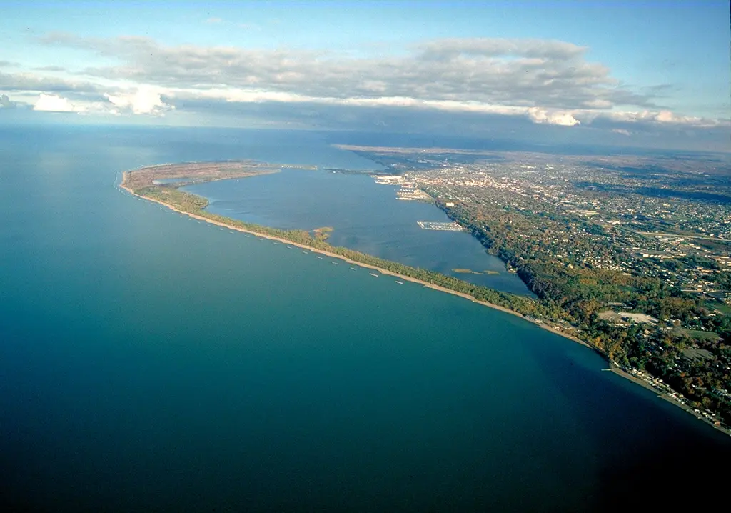

In Erie County, about 4 miles west of Erie, Presque Isle State Park covers about 2,001 acres.
Things to do include snorkeling and diving, cross-country skiing, winter sports, hunting in season, and canoeing and kayaking. Its trail network totals roughly 11 miles, according to the park. Facilities for water recreation include a swimming beach, a boat ramp, a fishing pier, and boat or kayak rentals.
Hours
Park, gate, office and facility hours are listed separately because they often differ. Alerts above override normal hours.
| Facility | Days | Hours | Season |
|---|---|---|---|
| Park | Daily | 5 a.m. – sunset | — |
| Mon–Fri | 8 a.m. – 4 p.m. | — |
Official wording
The park is open every day of the year, 5:00 A.M. to sunset. Day use areas close at dusk. After sunset, only tenants and people engaged in evening driving are permitted in the park. The Presque Isle State Park Office, located in the Tom Ridge Environmental Center, is open Monday through Friday from 8:00 A.M. until 4:00 P.M., except for major holidays. The beaches and other areas are open specific seasons and hours. Contact the park office for facility seasons and hours.
Source: official park page, checked Oct 29, 2026. Times are local to the park (America/New York).
Reservations
- Day use
- No day-use reservation requirement mentioned
- Booking system
- ReserveAmerica (Aspira), Pennsylvania State Parks contract
- Phone
- 888-PA-PARKS (888-727-2757)
We link to the official booking system rather than showing live availability, which changes minute to minute.
Pets
Dogs allowed
Swimming Area Pet Guidelines Inside designated guarded zones, leashed dogs are permitted in the tree line area only. Outside of designated guarded zones, leashed dogs are permitted on the sand and in the water. In addition, dogs must never be left unattended, and owners are responsible for cleaning up after their dogs.
Service animals are generally permitted where pets are not. Check with the park for specific areas.
Things to do
SwimmingWinter sportsCross-country skiingBoatingHuntingFishingHikingBikingSnorkeling and scubaPicnickingCanoeing and kayaking
Trails
| Trail | Length | Difficulty | Notes |
|---|---|---|---|
| A-Trail | 0.2 mi | Easiest | Recreations permitted: hiking Trailhead amenities: picnic tables This short trail connects Pine Tree Picnic Area to Dead Pond Trail. The trail passes through natural sand ridges. Some low areas of the trail are consistently covered in water due to flooding.Hiking |
| B-Trail | 0.25 mi | Easiest | Recreations permitted: hiking Trailhead amenities: none This short trail connects Pine Tree Road to Dead Pond Trail and passes through a stand of pines.Hiking |
| Canoe Portage Trail | 0.25 mi | Easiest | Recreations permitted: hiking, snowshoeing recommended Trailhead amenities: none This short walk between sand dunes and forest connects Pettinato Beach (Beach 8) to Marina Lake.HikingSnowshoeing recommended |
| Dead Pond Trail | 2 mi | Easiest | Recreations permitted: hiking, cross-country skiing recommended Trailhead amenities: none This trail leads over several former dunes and through several distinct ecological zones. Hikers will pass through oak-maple forest, pines, and sand plains.HikingCross-country skiing recommended |
| Duck Pond Trail | 0.5 mi | Easiest | Recreations permitted: hiking, snowshoeing recommended Trailhead amenities: benches This trail begins at Duck Pond and intersects the Canoe Portage Trail and connects with the Old Gas Well Trail. The northern section of the trail may be muddy.HikingSnowshoeing recommended |
| Fox Trail | 0.5 mi | Easiest | Recreations permitted: hiking, biking, cross-country skiing recommended Trailhead amenities: none This trail winds through wooded swamps and oak-maple forests proving a forested byway between Sidewalk Trail and a portion of the Multi-purpose Trail. It is maintained as a cross-country ski trail in the winter.HikingBikingCross-country skiing recommended |
| Graveyard Pond Trail | 0.75 mi | Easiest | Recreations permitted: hiking Trailhead amenities: modern restrooms. potable water, picnic tables, benches This trail follows the shoreline along Graveyard Pond, which legend says was the final resting place for many of Commodore Oliver Hazard Perry’s men during the winter of 1812-1814. Two boat landings along the trail offer scenic views of the lagoons and Big Pond.Hiking |
| Gull Point Trail | 1.5 mi | Most difficult | Recreations permitted: hiking, cross-country skiing recommended Trailhead amenities: modern restrooms, potable water, picnic tables This trail winds itself through Gull Point natural area. Hikers usually see all phases of succession in this constantly evolving area. From April 1 to October 31, access is only permitted on the trail surface due to nesting birds. Much of the trail is sandy, but portions are consistently becoming more wet or water covered due to changing lake elevations. Before hiking Gull Point Trail, visitors are encouraged to stop at the Tom Ridge Environmental Center to find oHikingCross-country skiing recommended |
| Karl Boyes Multi-Purpose National Recreation Trail | 13.5 mi | Easiest | Recreations permitted: hiking, biking, cross-country skiing Trailhead amenities: modern restrooms. potable water, picnic tables, benches ♿ This trail is ADA accessible. The Multi-Purpose Trail and extension makes a 13.5-mile circuit in the park. This paved trail is designated as a National Recreation Trail. This ADA accessible trail is popular with bicyclists, in-line skaters, and joggers. During the winter, the trail is plowed from the entrance to the Public Safety Building for hikers. For cross-country skiers, the trail is left snow covered from the Public Safety Building to Perry Monument.HikingBikingCross-country skiing |
| Long Pond Trail | 1 mi | Easiest | Recreations permitted: hiking, cross-country skiing recommended, snowshoeing recommended Trailhead amenities: benches This trail follows the shoreline of Long Pond, one of the ponds within the lagoon. About halfway along this trail is a boat landing, which is a popular fishing spot and offers a scenic view of the lagoon. The trail is usually wet and has active beaver activity including a channel the beavers have cut through the trail near the eastern trailhead.HikingCross-country skiing recommendedSnowshoeing recommended |
| Marsh Trail | 0.25 mi | Easiest | Recreations permitted: hiking, cross-country skiing recommended, snowshoeing recommended Trailhead amenities: none This trail bisects Cranberry Pond, one of the many ponds on Presque Isle and connects to several other trails. Songbirds move throughout the brush bordering both sides of the path.HikingCross-country skiing recommendedSnowshoeing recommended |
| North Pier Trail | 0.7 mi | Easiest | Recreations permitted: hiking Trailhead amenities: modern restrooms. potable water, benches This trail follows the shoreline between North Pier and Beach 11, along one of the sand ridges. An old firing range used for training during World War II may be seen along this trail.Hiking |
| Old Gas Well Trail | 0.5 mi | Easiest | Recreations permitted: hiking, cross-country skiing recommended, snowshoeing recommended Trailhead amenities: modern restrooms. potable water, picnic tables, benches This trail follows a ridge between Beach 7 and the Marina. The trail passes a gas well that produces gas used at Presque Isle State Park.HikingCross-country skiing recommendedSnowshoeing recommended |
| Pine Tree Trail | 0.7 mi | Easiest | Recreations permitted: hiking, snowshoeing recommended Trailhead amenities: none This trail follows the edge of a sand plain community and a stand of pines. Along this trail are the remains of the biology field lab that was used by Dr. O.E. Jennings to study plant succession on Presque Isle.HikingSnowshoeing recommended |
| Ridge Trail | 0.5 mi | Easiest | Recreations permitted: hiking, cross-country skiing recommended, snowshoeing recommended Trailhead amenities: none This trail follows the edge of Cranberry Pond along a portion of ridge that was a beach dune 300 years ago. Hike out-and-back or connect into several other trailheads for a longer hike.HikingCross-country skiing recommendedSnowshoeing recommended |
| Sidewalk Trail | 1.25 mi | Easiest | Recreations permitted: hiking, cross-country skiing recommended Trailhead amenities: none This historic trail was constructed by the U.S. Lighthouse Service as a path from the Presque Isle Lighthouse to the U.S. Lighthouse Service boathouse in Misery Bay. The trail was once a wooden boardwalk and was resurfaced with concrete in 1925.HikingCross-country skiing recommended |
Trail descriptions from the park
11 miles of trails
Bicycling and in-line skating are prohibited on hiking trails.
Due to fluctuating lake levels, portions of trails may be seasonally flooded and impassable without appropriate footwear.
Presque Isle State Park Map
PA Seaway Trail
The Seaway Trail, which follows the Lake Erie Shoreline through Erie County from New York to Ohio and includes the Karl Boyes Multi-purpose Trail, is designated as a Pennsylvania Scenic Byway.
Swimming
The sandy beaches, washed by the clear waters of Lake Erie, provide visitors with the only surf swimming within the Commonwealth of Pennsylvania.
Beaches are open daily from Memorial Day Weekend to Labor Day, unless otherwise posted.
The regular hours are 12:00 P.M. to 7:30 P.M.
People may not swim outside designated guarded zones; however, they may wade up to the knees -- no more than 10 feet from the shore.
For more information, call the park office at 814-833-7424.
Swimming Area Pet Guidelines
Inside designated guarded zones, leashed dogs are permitted in the tree line area only.
Outside of designated guarded zones, leashed dogs are permitted on the sand and in the water.
In addition, dogs must never be left unattended, and owners are responsible for cleaning up after their dogs.
Read more from the park
Smoke-Free Beaches
Smoking is prohibited on several Presque Isle State Park beaches. For visitors who smoke and still want to use the beach, designated areas adjacent to the beach are provided. The restriction includes:
- Cigarettes
- Pipes
- Cigars
- E-cigarettes
- Other handheld, lighted smoking devices
Beach 1
This long stretch of sand is located near the park entrance and has restrooms and a reservable pavilion.
Beach 3 (Barracks Beach)
Near Beach 1, this beach has restrooms and three first-come, first-served picnic pavilions.
This is a smoke-free beach.
Beach 6 (Lyons Beach)
This large beach has sand volleyball courts, a beach house with changing areas, and restrooms.
Beach 7 (Waterworks Beach)
In addition to restrooms, this beach features a ramp that provides access to the water’s edge. Beach wheelchairs are available at the Public Safety Building. This beach is adjacent to picnic areas, including playground equipment, the Rotary Pavilion, and other reservable picnic shelters.
Beach 8 (Pettinato Beach)
♿ In addition to changing areas and restrooms, this beach features a ramp that provides ADA access to the water’s edge. Beach wheelchairs are available at the Public Safety Building.
Mill Road Beaches
Stone Jetty, Short Jetty, Saw Mill, Ainsworth, Goddard
These beaches allow visitors to enjoy unspoiled, relatively quiet shoreline. Restrooms are at Saw Mill. Swimming is prohibited at the Mill Road Beaches. Visitors may walk the shoreline and use the shaded picnic areas.
This is a smoke-free beach.
Beach 9 (Pine Tree)
This beach has picnic facilities, a reservable picnic pavilion, and a restroom.
Beach 10 (Budny Beach)
Equipped with a beach house with changing areas and restrooms, this beach lies between the Sunset Point area (popular with kite flyers and wind surfers) and Gull Point.
Beach 11 (Kohler Beach)
This is the most sheltered beach and features shallow water, a large sandy beach, and a beach house with changing areas and restrooms. Beach #11 is adjacent to picnic areas, playground equipment, and a picnic pavilion.
This is a smoke-free beach.
Amenities
Facilities
- Picnic areas
- Picnic shelters
- Playground
- Nature center or museum
Water
- Swimming beach
- Boat ramp
- Marina or boat slips
- Boat, canoe or kayak rentals
- Fishing pier
✓ listed by the park · ✕ the park says it is not available. Anything not shown here isn’t mentioned by the official source — that means unknown, not unavailable.
Accessibility
Presque Isle State Park offers a range of accessibility accommodations to ensure all visitors can enjoy its natural beauty and recreational opportunities.
Accessible Picnic Tables
ADA picnic tables are located at the Waterworks area and at Beach 8.
Beach 11 Pavilion
The Beach 11 pavilion can accommodate up to 90 people at 10 picnic tables. Domestic pets are allowed.
Cookhouse Pavilion
The Cookhouse Pavilion can accommodate up to 230 people at 32 picnic tables. Domestic pets are allowed.
East Pier Pavilion
The East Pavilion can accommodate up to 50 people at 4 picnic tables. Domestic pets are allowed.
Erie Runners Club - Beach 1 Pavilion
The Erie Runners Club Pavilion at Beach #1 can accommodate up to 80 people at 10 picnic tables. Domestic pets are allowed.
Read more from the park
Perry Monument Pavilion
The Perry Monument pavilion can accommodate up to 90 people at 4 picnic tables. Domestic pets are allowed.
Pine Tree Pavilion
The Pine Tree pavilion can accommodate up to 90 people at 10 picnic tables. Domestic pets are allowed.
Rotary Pavilion
The Rotary Enclosed Pavilion can accommodate up to 100 people at 15 picnic tables. Domestic pets are allowed.
AAUW Pavilion
The AAUW Pavilion is located at the right side of the road as you near the entrance of the building.
Fishing Access
ADA accessible fishing piers are located throughout Presque Isle State Park.
East Pier
Ferry Dock
North Pier
Rotary Pavilion
West Pier
Karl Boyes Multi-Purpose National Recreation Trail
13.5 miles | Easiest hiking | Loop trail | No blazes
Recreations permitted: hiking, biking, cross-country skiing
Trailhead amenities: modern restrooms. potable water, picnic tables, benches
♿ This trail is ADA accessible.
The Multi-Purpose Trail and extension makes a 13.5-mile circuit in the park. This paved trail is designated as a National Recreation Trail. This ADA accessible trail is popular with bicyclists, in-line skaters, and joggers.
During the winter, the trail is plowed from the entrance to the Public Safety Building for hikers. For cross-country skiers, the trail is left snow covered from the Public Safety Building to Perry Monument.
13.5 miles | Easiest hiking | Loop trail | No blazes
♿ This trail is ADA accessible.
Hunting
There is an ADA duck blind at this park. It is available on a first come, first serve basis.
Visitors holding a DCNR Mobility Device Permit can contact the park office for more information about additional accessible hunting opportunities within the park.
DCNR permits visitors with a DCNR Mobility Device Permit to use powered mobility devices on designated state park and forest lands, including administrative roads and trails not normally open to standard motorized vehicles.
Visitors interested in a DCNR Mobility Device Permit can fill out an application and submit it at any state park or forest office.
Swimming and Beaches
An ADA accessible sand beach is located at Beach 8 and open from Memorial Day to Labor Day, 8:00 A.M. to sunset.
In addition to changing areas and restrooms, this beach features a ramp that provides ADA access to the water’s edge.
Beach wheelchairs are available at the Public Safety Building.
Swim at your own risk. Please read and follow posted rules.
The Turtle Observation Deck is Located Near the Lagoons/Graveyard Pond and is ADA accessible.
Sturgeon Bay Scenic Vista
Vista 1
Vista 2
Vista 3
Theaters and Amphitheaters
The theater inside the Tom Ridge Environmental Center (TREC) is ADA.
Playground
The Waterworks Playground is ADA accessible.
Communication Board
A communication board, a large visual aid that uses pictures and words to help non-verbal individuals express their needs, thoughts, and feelings, is located at the Waterworks playground.
A communication board, a large visual aid that uses pictures and words to help non-verbal individuals express their needs, thoughts, and feelings, is located at the TREC playspace.
Environmental Education and Visitor Centers
The Tom Ridge Environmental Center (TREC) is ADA accessible. Learn more about the TREC.
Historic Place
There are several ADA accessible historic places at Presque Isle State Park.
Perry Monument
Presque Isle Lighthouse
North Pier Light
Official accessibility information
Conditions change. Contact the park to confirm specific accessible features before your visit.
Getting there
- Address
- 301 Peninsula Drive
Erie, PA 16505-2042 - Nearest town
- Erie — about 4 mi west (straight line)
- Coordinates
- 42.1096, -80.1538
- Phone
- (814) 833-7424
- presqueislesp@pa.gov
Google Maps directionsApple MapsOfficial park map (PDF)
Directions from the park
Presque Isle State Park and the Tom Ridge Environmental Center can be reached by PA 832 north. The park can also be reached by boat. The road system within the park forms a loop approximately 13 miles in length. GPS DD: Lat. 42.10964 Long. -80.15384
Nearby state parks
Sources and freshness
- Pennsylvania State Parks — park page — last checked Oct 29, 2026; page says updated Sep 4, 2026
- DCNR Find a Park: content-fragment JSON feed used by the pa.gov park finder
- Wikidata
- USGS PAD-US 4.1 (boundary and acreage)
- Photo: Presque Isle Pennsylvania aerial view.jpg — Public domain (US federal government work), Ken Winters, U.S. Army Corps of Engineers
“Last checked” is when our system last read the official source. No change has been detected since this page was first published. Hours, fees and rules can change without notice — confirm with the park before you go. Methodology