Dead Horse Point State Park
- Status
- Open (per official listing)Daily 6 a.m. – 10 p.m.
- Entrance fee
- $20Annual pass available
- Day-use reservations
- Not requiredCan reach capacity
- Dogs
- Dogs allowed, with restrictions
- Camping
- Yes
- Official site
- stateparks.utah.gov(435) 259-2614
Official page last checked Oct 29, 2026. How we keep this current
Current alerts 1
Partial closure General advisoryNight Sky Viewing: Dead Horse Point State Park officially closes at 10 p.m. While the park is recognized as an International Dark Sky Park and our… (more)
Night Sky Viewing: Dead Horse Point State Park officially closes at 10 p.m. While the park is recognized as an International Dark Sky Park and our night sky viewing is phenomenal, day-use fees only extend to this closure time. We ask that visitors respect this closure by visiting other areas for night sky viewing if they intend to be out beyond this time. It is a perk of having a camping reservation that those staying in the campgrounds or yurts have access to the park beyond these hours. Joining a ranger-led activity or joining a company with a special use permit are also ways of experiencing the night skies beyond these hours. Learn more about our Dark Skies and Jr. Ranger Programs. Trail Markers: Dead Horse Point State Park has miles of hiking and mountain biking trails. The nature of this landscape makes marking trails difficult so they can be defined as “primitive trails.” Park rangers use piles of rocks called cairns, lines of rocks like curbs, and wood to mark trails. Because of this, we ask that visitors refrain from moving rocks or wood in any way along our trails. Stacking your own cairns or knocking them down confuses visitors, resulting in social trails and damage to…
Posted by the park. Official alert
Overview
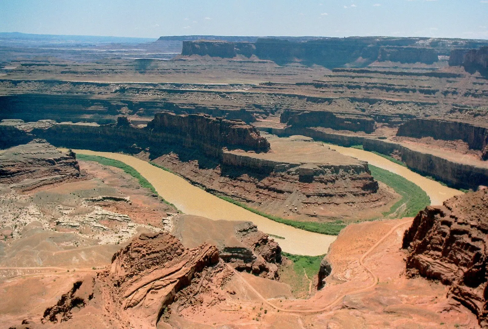

In Grand County, about 11 miles west of Moab, Dead Horse Point State Park covers about 4,339 acres.
Popular activities here are biking, ranger programs, hiking, and picnicking. Overnight options include 4 camping areas, with RV sites with full hookups and tent sites.
Hours
Park, gate, office and facility hours are listed separately because they often differ. Alerts above override normal hours.
| Facility | Days | Hours | Season |
|---|---|---|---|
| Park | Daily | 6 a.m. – 10 p.m. | — |
| Park | Closed: Thanksgiving, Christmas and New Year’s Day | ||
| Visitor center | Daily | 7 a.m. – 5 p.m. | — |
Official wording
Hours: Open year-round: 6:00 am – 10:00 pm
Closed: Thanksgiving, Christmas and New Year’s Day
WiFi: Available at Visitor Center: Emergencies: Call 911 in case of emergencies
Visitor Center: Open daily, 7 a.m. – 5 p.m.
Source: official park page, checked Oct 29, 2026. Times are local to the park (America/Denver).
Fees and passes
| Item | Amount |
|---|---|
| Entry reservations not required. | $20 |
| Day-Use Fees: Private Vehicle (High capacity) — | $2 |
| Per vehicle. | $15 |
| Day-Use Fees: Motorcycles — Per motorcycle | $10 |
| Valid date of purchase only. | $5 |
| Vehicle must be parked outside the park. | $10 |
| Annual Permits: Annual Permit (Standard) — Utah residents under age 65. (resident) | $125 · senior |
| Annual Permits: Annual Permit (Senior) — Utah residents age 65 or older. (resident) | $65 |
| Max 8 people. | $60 |
| Includes 1 vehicle, hookups, max 8 people. | $50 |
| Max 8 people. | $45 |
| Max 8 people. | $40 |
| Limit applies based on designated parking areas. | $20 |
| No pets. | $150 |
| No pets. | $100 |
Official wording
Day-Use Fees: Private Vehicle (Regular) — Up to 8 people. Entry reservations not required.: $20.00 Day-Use Fees: Private Vehicle (High capacity) — $2 per person after the first 8 people.: Varies Day-Use Fees: Utah Senior Day-Use — Utah residents 65 or older. Per vehicle.: $15.00 Day-Use Fees: Motorcycles — Per motorcycle: $10.00 Day-Use Fees: Commercial Vehicles — Per person. Includes all commercial tour groups. Valid date of purchase only.: $5.00 Day-Use Fees: Bike-In / Walk-In — Per group of 4 bicyclists or hikers. Vehicle must be parked outside the park.: $10.00 Annual Permits: Annual Permit (Standard) — Utah residents under age 65.: $125.00 Annual Permits: Annual Permit (Senior) — Utah residents age 65 or older.: $65.00 Camping - RV Sites: RV Campsite (Peak) — March, April, May, June, September, October. Includes 1 vehicle, 20/30/50 AMP, shade shelter, fire ring, dump station. No potable water fill. Max 8 people.: $60.00 Camping - RV Sites: RV Campsite (Off-Peak) — All other months. Includes 1 vehicle, hookups, max 8 people.: $50.00 Camping - Tent Only: Hike-In Tent Campsite (Peak) — Wingate Campground. March, April, May, June, September, October. Hike up to 300ft from restroom parking. Shade shelter, 15x16ft tent pad. Max 8 people.: $45.00 Camping - Tent Only: Hike-In Tent Campsite (Off-Peak) — Wingate Campground. All other months. Max 8 people.: $40.00 Camping Fees: Extra Camping Vehicle Fee — Per vehicle per night. Limit applies based on designated parking areas.: $20.00 Lodging - Yurts: Yurt Rental (Standard) — Includes park day-use fees & taxes. Includes climate control, power, beds (bunk + futon), mini fridge, microwaves, tables, deck BBQ grill. Sleeps max 6. No bedding provided. No pets.: $150.00 Lodging - Yurts: Yurt Rental (Discounted) — Applicable July 7 – Sept 1, Dec 1 – Dec 20, and Jan 3 – Feb 13. Max 6 people. No pets.: $100.00 + taxes
Utah park passes
- Annual Day-Use Pass (Standard) — $125. Day-use entrance for cardholder + up to 7 guests in one private vehicle, 12 months; Utah residents only; excludes Jordan River OHV SP, This Is The Place Heritage Park and the $2 Antelope Island causeway fee Details
- Senior Annual Pass (65+) — $65. As above, Utah residents 65+ Details
- Veterans with Disabilities Honor Pass — Free. Day-use for qualifying Utah veterans + up to 7 guests in the same vehicle Details
- Digital Day-Use Pass — varies by park. Single-day entry for 1 private vehicle (up to 8 people), valid on the calendar date of purchase Details
From the Utah state guide. Confirm which passes this park accepts.
Reservations
- Day use
- Not required
- Booking system
- ReserveAmerica (utahstateparks.reserveamerica.com)
- Phone
- 800-322-3770
Entry reservations not required.: $20.00
Fill your RV tanks before arriving: There is no water available for RV fill ups anywhere at Dead Horse Point State Park.
We link to the official booking system rather than showing live availability, which changes minute to minute.
Pets
Dogs allowed, with restrictions
Not allowed in or on: the wingate yurts.
Information about Traveling with Pets Can I bring dogs to the park? Like all of the Utah State Parks, Dead Horse Point is dog-friendly! Pet Guidelines: We ask that you respect the following guidelines: Leashed at all times: For the safety of yours pets, the wildlife, and the parks ecosystem, pets must be leashed at all times, even while in the campground Camping facilities: Pets are not allowed in the Wingate Yurts (or in vehicles outside the yurts). Moenkopi Yurts are pet friendly. Pets in vehicles: Pets cannot be left in vehicles due to extreme heat Clean up after your pet: Dog waste bag dispensers are located throughout the park. We hope you and your animal companions have fun out there!
Service animals are generally permitted where pets are not. Check with the park for specific areas.
Camping
| Campground or site type | Sites | Hookups / features | Price |
|---|---|---|---|
| RV Campsite (Peak) $60.00 March, April, May, June, September, October. Includes 1 vehicle, 20/30/50 AMP, shade shelter, fire ring, dump station. No potable water fill. Max 8 people. | — | — | |
| RV Campsite (Off-Peak) $50.00 All other months. Includes 1 vehicle, hookups, max 8 people. | — | — | |
| Hike-In Tent Campsite (Peak) $45.00 Wingate Campground. March, April, May, June, September, October. Hike up to 300ft from restroom parking. Shade shelter, 15x16ft tent pad. Max 8 people. | — | — | |
| Hike-In Tent Campsite (Off-Peak) $40.00 Wingate Campground. All other months. Max 8 people. | — | — |
Camping details from the park
Lodging and Camping RVs and Water Fill your RV tanks before arriving: There is no water available for RV fill ups anywhere at Dead Horse Point State Park. If you do need to fill up RV tanks before arriving there are multiple options in Moab on 191 and Green River on I-70. Available Camping Options • Day-Use: Open year-round • Moenkopi Yurts: Open year-round • Kayenta Campground: Open until November 30 • Wingate Campground & Yurts: Open year-round. Dump station open. Kayenta Campground Nestled within a grove of junipers, the Kayenta Campground at Dead Horse Point State Park offers a peaceful, shaded respite from the surrounding desert. All 21 campsites offer lighted shade structures, picnic tables, fire rings, and tent pads. All sites are also equipped with RV electrical hookups (20/30/50 AMP). Modern restroom facilities are available, and hiking trails lead directly from the campground to various points of interest within the park including the West Rim Trail, Wingate Campground, or the Visitor Center. Learn more Wingate Campground & Yurts The Wingate Campground sits atop the mesa with far-reaching views of the area’s mountain ranges and deep canyons. This campground contains thirty-one (31) campsites, twenty (20) of which have electrical hookups that support RV, or tent campers, while eleven (11) are hike-in tent-only sites. This means a physical tent is required. Camper vans and rooftop tent reservations will be voided upon arrival, no exceptions. The Wingate Campground also holds four yurts. No dogs allowed. Learn more Moenkopi Yurts Each yurt of the five Moenkopi yurts contains sleeping space for up to six people, in the form of a bunk bed (bottom bunk is a queen mattress, top bunk is a full mattress) and a pullout futon couch (full mattress). A mini fridge and microwave are provided, and an outdoor propane grill allows for cooking on-site. The park provides the propane Heating, air conditioning, and electrical outlets are available, and tables are available both inside and outside of the yurt. Learn more Things to Know A maximum number of 8 people and one “camping unit” are allowed at each site. Definition of Camping Units: Dead Horse Point State Park has defined “camping units” as RVs, camping trailers, pop-up trailers, sprinter vans, and any other vehicle that has been built, or augmented, for the sole purpose of long-term camping. A combination of one camping unit and tents may be used as long as the tents are only on the tent pad or asphalt section of the camping site. No exceptions to these standards.
From the official park page, checked Oct 29, 2026. Site counts and prices can change; confirm when booking.
Cabins and lodging
- Yurt Rental (Standard)$150.00 Includes park day-use fees & taxes. Includes climate control, power, beds (bunk + futon), mini fridge, microwaves, tables, deck BBQ grill. Sleeps max 6. No bedding provided. No pets.
- Yurt Rental (Discounted)$100.00 + taxes Applicable July 7 – Sept 1, Dec 1 – Dec 20, and Jan 3 – Feb 13. Max 6 people. No pets.
Things to do
HikingBikingCampingRanger and interpretive programsPicnicking
Trails
Hiking Rim Hiking Trails About seven miles of hiking trails navigate the rimrock and desert plateau landscape of Dead Horse Point State Park, connecting nine different overlooks. All trails are relatively easy in nature, traversing the mesa top with minimal elevation gain or loss. Because of uneven slick rock, however, sturdy footwear is highly recommended. Dogs: Dogs are allowed on hiking trails, but must be kept on a leash at all times. Overlook Trail Difficulty: Easy (200 feet one way) This is the main attraction of Dead Horse Point State Park. From the overlook parking lot, a short paved ADA accessible pathway leads to breathtaking views of the Colorado River and adjacent canyon country some 2,000 feet below. A large shelter at the overlook provides relief from both foul weather and summer heat. Paved pathways lead out in both directions from the shelter, providing additional viewpoints while linking up with both the East and West Rim trail systems these pavement sections are not ADA accessible. Although the primary overlook and shade shelter are accessible, the eastern and western spur trails contain steeper inclines and short sections of slick rock interspersed with the pavement. Visitor Center Nature Trail Difficulty: Easy (1/8 mile one-way) The paved path just outside the Visitor Center offers great views of the basin to the east, the La Sal Mountains and Chimney Rock. Eight trail-side exhibits highlight some of the common desert plants and trees that you’re likely to encounter in the park, while an interpretive sign explains a unique feature that can be seen from many of the East Rim overlooks: solar evaporation ponds that are used in the mining of salt and potash. Desert View Overlook Difficulty: Easy (0.5 miles one way) This trail winds north from the visitor center, skirting along the east rim to a view of the canyon bottom below and glimpses of the Colorado River and Potash Ponds. The view from the overlook allows visitors a wonderful spot to sit and see all of the rock layers that have been exposed by millions of years of erosion. Check out the ephemeral pools (potholes) for fairy shrimp, whirligig beetles, toad tadpoles and other tiny desert life. Juniper Tree groves give potential to seeing other larger wildlife. Keep a look out for rabbits, lizards, mule deer and maybe even bighorn sheep. East Rim Trail System Difficulty: Easy (1.5 – 2 miles one way) This trail begins at the south side of the visitor center and travels south along the eastern side of the mesa top to Dead Horse Point, providing a fun hiking alternative to simply driving the park’s main road. The East Rim offers great views towards the La Sal Mountains and Behind the Rocks area as well as sagebrush flats and juniper forest. Aside from a short hill a quarter-mile from the visitor center, this trail is predominantly flat. A loop of this and the West Rim Trail makes a great 5-mile (or more), half-day adventure starting and stopping at the visitor center. By itself, the East Rim Trail amounts to 1.5 miles between the visitor center and Dead Horse Point. An additional half-mile can be added by taking the Basin Overlook spur. This side trail quickly drops about 100 feet off the mesa top to a shelf that offers spectacular, and typically more secluded views of the canyon country below. West Rim Trail System Difficulty: Moderate (2.5 – 3.5 miles one way) The West Rim is the longest hiking trail at Dead Horse Point State Park. From the visitor center, the route crosses the road and passes briefly through the campground before following the cliffs that form the western boundary of the park. This trail is more primitive, and usually less traveled than the East Rim. Make sure to follow the cairn-marked routes over exposed sections of sandstone and slick rock. The Meander, Shafer, and Rim overlook spur trails add an additional mile to the trek while affording sweeping vistas of Shafer Canyon and the Colorado River. Bighorn Overlook Trail Difficulty: Moderate (1.5 miles one way) This is the longest spur off the West Rim Trail, branching off to the north from the vicinity of the Kayenta campground. Because of its isolation (you may well be the only group on the trail) and the fact that its views rival those of Dead Horse Point itself, this trail can be considered a destination of its own. The overlook is named for an eroded fin that can be seen in the distance, resembling a pair of horns. The end of the trail is also home to a series of very deep potholes which, when filled with water, can be teeming with fairy shrimp, tadpoles, and other forms of aquatic desert life. Like the other West Rim trails, this route often follows cairns across stretches of slick rock. There also are short sections of moderate cliff exposure, especially at the overlook itself where there are no guardrails. Caution and sturdy footwear are advised. Mixed Use Trails Hiking and Biking: Measuring nearly six miles in total, the new (2025) mixed use trail system along Dead Horse Point’s far east rim takes adventurers on a true backcountry experience. Seven (7) unique overlooks grant sweeping vistas of the Colorado River canyon country, as well as mining operations past and present. View Mixed-Use Trails Mixed-Use Trails The Intrepid Trail System at Dead Horse Point State Park offers more than 17 miles of non-motorized trails. Moab Trail Mix, with a generous donation from Intrepid Potash Inc., completed the system in 2014. Mixed-Use Trails - 7 Unique Overlooks: Measuring nearly six miles in total, the new (2025) mixed use trail system along Dead Horse Point’s far east rim takes adventurers on a true backcountry experience. Seven unique overlooks grant sweeping vistas of the Colorado River canyon country, as well as mining operations past and present. At its eastern terminus, the system ends at an intact historic site where early 1950’s oil workers extended an equipment cable line all the way to their operation at the river, some 2,000 feet below. The trails wind through juniper and pinyon trees, over slick rock and mixed terrain and offer spectacular views into the canyons below. Trail difficulty varies, with options that can be enjoyed by beginners, families and expert riders alike. Main Trailhead: The main trailhead is located one mile south of the Entrance Station. The secondary trailhead and parking area are also accessible via the north side of the Visitor Center Parking lot. Mountain bikers should only use this when the primary lot is full. Know before you go: Please note that this is the most remote section of Dead Horse Point State Park. Basic route finding skills are required and because the trails are not specifically maintained for mountain bikes, all should be considered difficult with scattered obstacles. Cell reception along the far east rim is generally spotty at best. A park day-use entrance fee is required on a per-vehicle basis (valid for two consecutive days). Dogs: Dogs are allowed on the mountain biking trails, as long as they are on a leash AT ALL TIMES. Trail Descriptions Note: These descriptions follow a generally counter-clockwise and easy-difficult loop around the Intrepid trail system. Trail difficulties are relative to the Intrepid Trail network only, and should not be used in comparison with any other system. If you are hiking on these trails, remember bikers can be present. Trail Maps: Maps can be found at trail junctions. Please note that riders must dismount when crossing the park road. Intrepid Length: 1/2 mile Average biking time: 4-5 minutes Difficulty: Easy All mountain biking adventures start here. Intrepid is a short trail that is excellent for beginners. Rocky terrain is present, but there is little elevation change. The end of the trail has an excellent view from the Desert View Overlook. From Intrepid, one may continue on to the Great Pyramid Trail, turn north onto Raven Roll, or cross the park entrance road and proceed to the more challenging western rim trails. Great Pyramid Length: 2.2 miles Average biking time: 20-25 minutes Difficulty: Easy to Moderate Great Pyramid is a fun, well-lined trail. Less than a mile after splitting off from Intrepid, the overlook is reached, giving another sweeping view down toward the Colorado River and toward a formation known as the “Great Pyramid” in the distance. Beyond the overlook, to its intersections with Big Chief and Raven Roll, the trail consists of semi-rocky terrain and varied elevation. Traveling southbound will allow riders to enjoy some downhill slick rock areas. Raven Roll Distance: 1.7 miles Average biking time: 8-12 minutes Difficulty: Easy Raven Roll is a fast-moving, semi-sandy trail that varies in elevation. It can be taken in either direction but rides best (fastest) from north to south. For those looking for shorter rides along the east rim, Raven Roll provides for an easy 4-mile loop with Great Pyramid or a more moderately difficult 8-mile loop with Big Chief. Big Chief Distance: 3.6 miles Average biking time: 32-38 minutes Difficulty: Easy to Moderate Big Chief is a fun trail to ride in either direction. There is plenty of slick rock and elevation change throughout, making this the most challenging trail on the eastern side of the Intrepid system. At the northernmost point, riders will come to the “Big Chief Overlook,” which provides a sweeping vista of the canyons and La Sal Mountains to the east – as well as the butte for which the trail and overlook are named. A 0.7 mile spur trail leads to the historic “Miner’s Point,” which used to be the final point of an oil line reaching all the way down to the Colorado River. Crossroads Distance: 1.7 miles Average biking time: 11-15 minutes Difficulty: Easy to Moderate As the name implies, Crossroads connects Big Chief and Raven Roll on the east rim with Whiptail and Prickly Pair on the west. Well packed with a series of short dips and rollers, this is a fun and fast-paced trail in its own right. Crossroads is best ridden from west to east but can be taken in either direction. Please note that riders must dismount when crossing the park road. Whiptail Distance: 2.6 miles Average biking time: 22-26 minutes Difficulty: Moderate Extending to the park’s western boundary, Whiptail is a fun track that hosts an overlook into Shafer Canyon 1,000 feet below. Dropping in elevation from north to south, the trail is smooth and fast-paced. Intersections with cut-off spurs from both Twisted Tree and Prickly Pear allow for a variety of possible loops. Twisted Tree Distance: 1.5 miles Average biking time: 15-18 minutes Difficulty: Moderate to Difficult Twisted Tree is a fun, scenic, and mildly technical ride that follows the rim of Shafer Canyon for more than a mile. The riding here is often on slick rock instead of dirt and sand. The westernmost 1/3 mile of the trail serves as a cutoff that divides Whiptail in two, allowing for differing loop options. Use caution, however, as the cutoff is one of the most difficult sections of the track in the park. Prickly Pair Distance: 2.2 (Prickly) or 1.8 miles (Pair) Biking time: 24-26 minutes (Prickly) or 16-18 minutes (Pair) Difficulty: Moderate to Difficult Depending on the direction one chooses from the start of the Intrepid system, Prickly Pair is either the first or last trail that will be encountered. The trail can actually serve as a short, mildly technical loop of its own, using both the “Prickly” and “Pair” segments. “Prickly” is the more difficult of the two options, consisting of a lot of slick rock and varying elevations. It is also the more scenic option, granting the occasional glimpse of Shafer Canyon to the west. Riding in either direction is sure to be a fun test of your skills. “Pair” is a more moderate alternative, and also a quicker way to pass through this section of trail. Light sand and slick rock sections will still pose an enjoyable challenge. Crossing over a small ridge also means that riders will experience both uphill and downhill sections while traveling in either direction. Bike Rentals - Big Horn Mountain Biking Bighorn Mountain Biking offers mountain bike rentals right from the intrepid trailhead! Skip the crowds and enjoy mountain biking through the desert to pristine overlooks. This family friendly trail system includes beginner and intermediate trail options that provide fun for everyone. Book in advance with Big Horn Mountain Biking to ensure bikes availability. Rent a Bike
Amenities
Facilities
- Restrooms
- Drinking water
- Picnic areas
- Picnic shelters
- Visitor center
- Restaurant or food service
- Parking
Camping
- Tent camping
- RV camping
- Electric hookups
- Sewer hookups
✓ listed by the park · ✕ the park says it is not available. Anything not shown here isn’t mentioned by the official source — that means unknown, not unavailable.
Accessibility
This is the main attraction of Dead Horse Point State Park. From the overlook parking lot, a short paved ADA accessible pathway leads to breathtaking views of the Colorado River and adjacent canyon country some 2,000 feet below. A large shelter at the overlook provides relief from both foul weather and summer heat. Paved pathways lead out in both directions from the shelter, providing additional viewpoints while linking up with both the East and West Rim trail systems these pavement sections are not ADA accessible. Although the primary overlook and shade shelter are accessible, the eastern and western spur trails contain steeper inclines and short sections of slick rock interspersed with the pavement. Main Trailhead: The main trailhead is located one mile south of the Entrance Station. The secondary trailhead and parking area are also accessible via the north side of the Visitor Center Parking lot. Mountain bikers should only use this when the primary lot is full.
Official accessibility information
Conditions change. Contact the park to confirm specific accessible features before your visit.
Rules and permits
Special Use Permits Information on: Special Use Permits, Weddings and Drone Regulations Special Use Permits Note: This page applies only to Dead Horse Point State Park. We cannot process, approve, or advise on any permit for any other park or jurisdiction. SPECIAL USE PERMITS are required for any event or activity beyond the activities of normal park use. Commercial activities such as filming, photography, hiking tours, biking tours, workshops and weddings all require a special use permit. How to apply Contact the park to complete the SUP application. When are applications due? Complete the application at least 30 days prior to the event. Some commercial activities will need to supply a current commercial general liability COI (listing Utah State Parks, 1594 W. North Temple #116, Salt Lake City, UT 84116 as additionally insured). Required limits vary depending on the activity/event. For more information or to submit an application packet, please contact Elizabeth Cappa, Assistant Park Manager, at ecappa@utah.gov Weddings Wedding and Elopement Ceremonies: Dead Horse Point offers multiple ceremony sites that can accommodate a variety of groups sizes ranging from less than 5 and up to 100 people. DHP wedding site location map For more ceremony site information please check out the DHP Wedding Packet. If you have any questions regarding availability or the permitting process please reach out to DHP’s Assistant Park Manager at ecappa@utah.gov. If you call the park you will be directed to this email for all permit processes and questions. Wedding Permits: ALL weddings are required to have a special use permit. Applications will be accepted 1 month to 18 months in advance of the planned date. Spring and Fall dates are the most popular and fill up fast! Applications for Memorial Day Weekend (Friday-Monday) will not be approved due to high visitation and potential park carrying capacity closures. To apply, please fill out the Weddings/Elopements SUP Application. If you have any questions regarding availability or the permitting process, please reach out to Elizabeth Cappa, Assistant Park Manager, at ecappa@utah.gov . If you call the park you will be directed to this email for all permit processes and questions. Portrait Sessions: While we do not currently require a permit for these activities, the hired photographer will need to have a Special Use Permit to operate their business in the park. Photographers and Event Service Providers: Please complete the Wedding/Portrait Photography and Event Services SUP Application. You can apply for a single session/event (single use punch card) or multiple sessions/events (a renewable (with an active COI on file) 5 session punch card). If approved, you will need to submit your current commercial general liability COI (listing Utah State Parks, 1594 W. North Temple #116, Salt Lake City, UT 84116 as additionally insured) to Elizabeth Cappa, Assistant Park Manager, at ecappa@utah.gov . If you call the park you will be directed to this email for all permit processes and questions. Drone Regulations Dead Horse Point is a small state park that often experiences high levels of visitation. In order to protect people's’ privacy and enjoyment, along with the well-being of wildlife, drones are prohibited from March through October of each year throughout the entire park. Winter Restrictions: Between November 1st and the last day of February of each year, drone use is permitted by permit only. Permits cost $10 per day and forms may be obtained online or at the visitor center. Please download the form and bring it with you to expedite the approval process at the visitor’s center. Permits must be approved by park staff at the visitor center (open 9 a.m. - 5 p.m.; closed Thanksgiving, Christmas and New Years’). Commercial permits are also available for Commercial Filming as an attachment to the Special Use Permit application. Permitted operators must follow special regulations to respect the traditional visitor experience and protect sensitive resources as listed on the permit forms. The following are park-specific regulations that apply to operating a drone at Dead Horse Point State Park: • Because of the high use by park visitors drone operation at the main viewpoint of Dead Horse Point is not permitted. • Park staff have the authority to enforce regulations and check agency-issued permits at any time and violations of the rules can result in a revocation of permit privileges.
Getting there
- Nearest town
- Moab — about 11 mi west (straight line)
- Coordinates
- 38.5163, -109.7300
- Phone
- (435) 259-2614
Nearby state parks
Sources and freshness
- Utah State Parks — park page — last checked Oct 29, 2026; page says updated Sep 21, 2026
- Utah State Parks WordPress REST API, custom post type 'parks', top-level posts with acf.page_type = 'parent' (50 = 46 state parks + 4 State Monuments)
- Wikidata
- USGS PAD-US 4.1 (boundary and acreage)
- Photo: Dead Horse Point State Park01.jpg — Public domain (released by the author), Nikater
“Last checked” is when our system last read the official source. No change has been detected since this page was first published. Hours, fees and rules can change without notice — confirm with the park before you go. Methodology