Beltzville State Park
- Status
- Status not postedDaily sunrise – sunset
- Entrance fee
- Not posted
- Day-use reservations
- None mentioned
- Dogs
- Not stated — check with park
- Camping
- None listed
- Official site
- pa.gov(610) 377-0045
Official page last checked Oct 29, 2026. How we keep this current
Overview
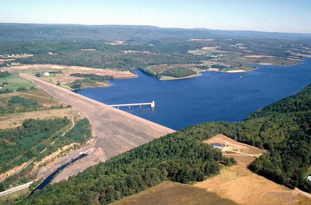

In Carbon County, about 4 miles north of Palmerton, Beltzville State Park covers about 7,115 acres.
Popular activities here are cross-country skiing, mountain biking, winter sports, hunting in season, and canoeing and kayaking. Its trail network totals roughly 15 miles, according to the park. On the water side, there is a swimming beach, a boat ramp, and boat or kayak rentals.
Hours
Park, gate, office and facility hours are listed separately because they often differ. Alerts above override normal hours.
| Facility | Days | Hours | Season |
|---|---|---|---|
| Park | Daily | sunrise – sunset | — |
| Daily | 8 a.m. – 8 p.m. | Memorial day to labor day | |
| Daily | 8 a.m. – sunset | — |
Official wording
The park is open every day of the year sunrise to sunset. The beach and day use areas are open specific seasons and hours: From Memorial Day to Labor Day, the beach and day use area are open every day from 8:00 AM to 8:00 PM. During the remainder of year, the day use area is open every day from 8:00 AM to dusk. The park office is open specific hours. Contact the park office for facility seasons and hours.
Source: official park page, checked Oct 29, 2026. Times are local to the park (America/New York).
Reservations
- Day use
- No day-use reservation requirement mentioned
- Booking system
- ReserveAmerica (Aspira), Pennsylvania State Parks contract
- Phone
- 888-PA-PARKS (888-727-2757)
We link to the official booking system rather than showing live availability, which changes minute to minute.
Things to do
HikingSwimmingBoatingBikingMountain bikingWinter sportsCross-country skiingPicnickingHuntingFishingCanoeing and kayaking
Trails
| Trail | Length | Difficulty | Notes |
|---|---|---|---|
| Bird Blind Trail | 0.1 mi | Easiest | Recreations permitted: hiking, cross-country skiing recommended Trailhead amenities: none The Bird Blind Trail is a short trail that starts near the Ground Pine Trail and continues to a wall-type bird blind. Visitors must turn around just past the bird blind, and obey all “No Trespassing” signs in the area.HikingCross-country skiing recommended |
| Christman Trail | 2 mi | More difficult | Recreations permitted: hiking, mountain biking, cross-country skiing recommended Trailhead amenities: none The trail leads past an old orchard, through a mixed forest, and through old farm fields. The easy main loop is marked with yellow medallions, and connects with the Wild Creek Trail.HikingMountain bikingCross-country skiing recommended |
| Cove Ridge Trail | 2.4 mi | More difficult | Recreations permitted: hiking Trailhead amenities: none Accessed by the Wild Creek Trailhead, the Cove Ridge Trail begins at the Wild Creek Falls Bridge and follows the forested ridge above Wild Creek Cove.Hiking |
| Falls Trail | 1 mi | More difficult | Recreations permitted: hiking Trailhead amenities: none Accessed by the Wild Creek Trailhead, the Falls Trail leads to the Wild Creek Falls Bridge and then leads upstream to the waterfalls area.Hiking |
| Ground Pine Trail | 1.2 mi | Easiest | Recreations permitted: hiking, cross-country skiing recommended Trailhead amenities: none The entrance to this relatively easy loop trail is located behind the park office. The trail leads through a mixed forest and loops back to the park office.HikingCross-country skiing recommended |
| Pine Run Cove Trail | 0.7 mi | Easiest | Recreations permitted: hiking, cross-country skiing recommended Trailhead amenities: none The trail begins at the southeast corner of Parking Lot A. This relatively easy trail follows a path along the Pine Run Cove and loops back through a field area.HikingCross-country skiing recommended |
| Preachers Camp Trail | 2.4 mi | More difficult | Recreations permitted: hiking Trailhead amenities: modern restrooms at Preachers Camp Boat Launch The trail can be accessed from the end of Preachers Camp Road or the parking lot off Trachsville Hill Road. This moderately difficult trail ascends the steep mountainside through deciduous and coniferous forests. It cuts through a thick section of rhododendron understory, as it follows the Pohopoco Cove.Hiking |
| Sawmill Loop Trail | 2 mi | More difficult | Recreations permitted: hiking Trailhead amenities: none Looping along the Sawmill Run Creek, the trail passes by mixed forest with large Eastern hemlocks, fields, a pond, and a forested swamp. There are several historical points of interest along this trail, such as several dams and the remnants of a water raceway for a grist mill. An abandoned slate quarry dates back to the 18th and 19th century.Hiking |
| Tree ID Trail | 0.2 mi | Easiest | Recreations permitted: hiking Trailhead amenities: none The short Tree ID Trail begins near Parking Lot B and ends near the Ground Pine Trail. Along the trail, identify trees using a pamphlet -- available at the trailhead or in the park office.Hiking |
| Trinity Gorge Trail | 4.1 mi | More difficult | Recreations permitted: hiking Trailhead amenities: modern restrooms at Preachers Camp Boat Launch This trail leads past farm fields and through forests for 2.9 miles between the two trailheads. An optional 1.2-mile section of the trail follows the lakeshore to make a loop in the middle of the trail.Hiking |
Trail descriptions from the park
15 miles of trails
Varying in length, the trails follow wooded paths, old roads, and mowed walkways through forests, creek valleys, fields, and by the lake.
Beltzville State Park Map
Mapa del Parque Estatal Beltzville
Swimming
A 525-foot sand beach is open from late-May to Labor Day, 8:00 A.M. to sunset.
Swim at your own risk. Please read and follow posted rules for swimming. Recreational scuba diving is prohibited.
A bathhouse with showers is near the beach.
A food and refreshment concession at the swimming beach is open daily, weather permitting, during the summer season, Memorial Day to Labor Day.
Smoke-Free Beach
Smoking is prohibited on the beach and in the swimming area. For visitors who smoke and still want to use the beach, designated areas adjacent to the beach are provided. The restriction includes:
- Cigarettes
- Pipes
- Cigars
- E-cigarettes, and other handheld, lighted smoking devices
Amenities
Facilities
- Picnic areas
- Picnic shelters
Water
- Swimming beach
- Boat ramp
- Marina or boat slips
- Boat, canoe or kayak rentals
✓ listed by the park · ✕ the park says it is not available. Anything not shown here isn’t mentioned by the official source — that means unknown, not unavailable.
Accessibility
Beltzville State Park offers a range of accessibility accommodations to ensure all visitors can enjoy its natural beauty and recreational opportunities.
Pavilion 1
Pavilion 2
Pavilion 4
Water Access
There are several accessible boat launches available at Beltzville State Park.
Pine Run East Launch - ADA boat launch
Day Use Area - ADA courtesy dock available upon request
Kayak Launch - An ADA kayak launch is available at the Preachers Camp boat launch.
Hunting
This park offers accessible hunting options. Visitors holding a DCNR Mobility Device Permit can contact the park office for more information about accessible hunting locations within the park.
DCNR permits visitors with a DCNR Mobility Device Permit to use powered mobility devices on designated state park and forest lands, including administrative roads and trails not normally open to standard motorized vehicles.
Read more from the park
Visitors interested in a DCNR Mobility Device Permit can fill out an application and submit it at any state park or forest office.
Swimming and Beaches
An ADA accessible, 525-foot sand beach is open from late-May to Labor Day, 8:00 A.M. to sunset.
There is a paved access ramp from the parking lot to the beach and into the water.
Swim at your own risk. Please read and follow posted rules.
GPS DD: 40°51'33.3"N 75°37'36.7"W
Official accessibility information
Conditions change. Contact the park to confirm specific accessible features before your visit.
Getting there
- Address
- 2950 Pohopoco Drive
Lehighton, PA 18235-8905 - Nearest town
- Palmerton — about 4 mi north (straight line)
- Coordinates
- 40.8647, -75.6290
- Phone
- (610) 377-0045
- beltzvillesp@pa.gov
Google Maps directionsApple MapsOfficial park map (PDF)
Directions from the park
Beltzville is five miles east of Lehighton, just off US 209. From the Northeast Extension of the Pennsylvania Turnpike, take Exit 74 and follow the signs to the park. GPS DD: Lat. 40.86468 Long. -75.629
Nearby state parks
Sources and freshness
- Pennsylvania State Parks — park page — last checked Oct 29, 2026; page says updated Sep 3, 2026
- DCNR Find a Park: content-fragment JSON feed used by the pa.gov park finder
- Wikidata
- USGS PAD-US 4.1 (boundary and acreage)
- Photo: USACE Beltzville Dam and Lake.jpg — Public domain (US federal government work), Anthony Bley, U.S. Army Corps of Engineers
“Last checked” is when our system last read the official source. No change has been detected since this page was first published. Hours, fees and rules can change without notice — confirm with the park before you go. Methodology