Emerald Bay State Park
Also known as Emerald Bay SP
- Status
- Open (per official listing)Daily sunrise – sunset
- Entrance fee
- $3 parkingAnnual pass available
- Day-use reservations
- None mentioned
- Dogs
- Dogs allowed, with restrictions
- Camping
- Yes
- Official site
- parks.ca.gov(530) 541-3030
Official page last checked Oct 30, 2026. How we keep this current
Overview
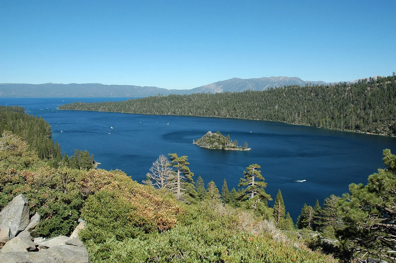

In El Dorado County, about 7 miles west of South Lake Tahoe, Emerald Bay State Park covers about 1,340 acres.
The park supports snorkeling and diving, historic sites, boating, swimming, and fishing. The official site lists about 7.4 miles of trails. Facilities for water recreation include a swimming beach and boat or kayak rentals. Overnight options include campsites, with RV sites, tent sites, and showers.
Hours
Park, gate, office and facility hours are listed separately because they often differ. Alerts above override normal hours.
| Facility | Days | Hours | Season |
|---|---|---|---|
| Park | Daily | sunrise – sunset | — |
Official wording
Sunrise to Sunset
Seasons/Climate: Summer temperatures range from about 75 degrees during the day to the low 40s at night, and winter temperatures average from a high of 40 to a low of 20 degrees; during extremely cold winters Emerald Bay freezes over. High Sierra weather is varied and can change abruptly. It is recommended to bring layered clothing and check weather updates. Weather forecast is available at NOAA. Chains and/ or 4 wheel drive are frequently required during the winter season. For up to date road conditions, call the Caltrans road hotline at 1800-427-ROAD, or visit the Caltrans website. Emerald Bay State Park is located off of Highway 89.
Source: official park page, checked Oct 30, 2026. Times are local to the park (America/Los Angeles).
Fees and passes
| Item | Amount |
|---|---|
| Hourly Parking | $3 |
| Vehicle Day Use | $10 |
Official wording
Special rates may apply for peak season, high demand holiday periods, and during weekends. Prices are subject to change without notice. • Hourly Parking: $3.00 • Vehicle Day Use: $10.00
California park passes
- California Explorer Annual Pass — $195. Vehicle day-use entry to 134 state parks incl. high-demand Southern California beaches Details
- Golden Poppy Annual Pass — $125. Vehicle day-use entry to 112 state parks Details
- Historian Passport — $50. Admission for up to four people at per-person-fee State Historic Parks Details
- Off-Highway Vehicle (OHV) Annual Pass — $50. Entry to State Vehicular Recreation Areas that collect day-use fees Details
- SNO-Park Pass — $40 season / $15 day. 18 SNO-PARK winter recreation areas Details
From the California state guide. Confirm which passes this park accepts.
Reservations
- Day use
- No day-use reservation requirement mentioned
- Booking system
- ReserveCalifornia
- Phone
- (800) 444-7275
We link to the official booking system rather than showing live availability, which changes minute to minute.
Pets
Dogs allowed, with restrictions
Not allowed in or on: any trails or roads into emerald bay; most areas in emerald bay state park; any areas on land; the rubicon trail or the entire grounds surrounding the vikingsholm mansion or fannette island.
Are dogs allowed? Rubicon Trail hiking - OPEN- No dogs allowed. No Dogs - Dogs are not allowed on any trails or roads into Emerald Bay, nor on the beach. Dog regulations are enforced year-round. DOGS For the protection of our wildlife, natural resources and for the comfort and enjoyment of all our park visitors, dogs are not allowed in most areas in Emerald Bay State Park. Dogs are not allowed in any areas on land, including beaches, dirt trails, service roads from highway 89 going down into Emerald Bay, Boat camp, and Vikingsholm. Dogs are not allowed on the Rubicon Trail or the entire grounds surrounding the Vikingsholm Mansion or Fannette Island. Dogs are allowed on boats and at the vista overlook at the Vikingsholm Trail parking lot. Please do not leave your dog in a vehicle and plan accordingly. Here are some boarding options if you are away from home and more information on Dogs in CA State Parks Some other areas that do allow dogs:
Service animals are generally permitted where pets are not. Check with the park for specific areas.
Camping
CAMPING
Eagle Point Campground opens June 12th. Hikers are welcome to walk in to access the Rubicon trailhead. No dogs on the trail. From Eagle Point entrance to Vikingsholm is almost 2.5 miles.
Reservations for camping can be made six months in advance of the date of your arrival. 1-800-444-7275.
Quiet Hours 10pm - 6am
Generator Hours 10am - 8pm
Check In - 2 pm
Check Out - Noon
1-2 Vehicles per campsite (site specific)
4-8 people per campsite (site specific)
Dogs must be leashed and never unattended
Children must have helmets for bicycles/scooters/skateboards
Vehicles must be parked on pavement
Amplified music is only allowed with a permit
All CA vehicle regulations apply - no passengers in truckbed
Read more from the park
Food must be stored DAY and NIGHT
Food Storage Locker Information - IMPORTANT AND REQUIRED
All food, beverages, and toiletries are required by law to be stored in provided food lockers during DAY and NIGHT, except when food is being prepared or eaten. Black bears are currently very active in Emerald Bay! Metal bear-resistant food lockers are provided in each campsite. Ice chests may NOT be stored in vehicles and shall be stored in the bear locker. The inside dimensions of the food lockers 36" deep, 43" wide, and 22" high. Violations will be cited.
Food, beverages, ice chests, and trash must be stored in food lockers during NIGHT and DAY hours.
Are you considering a Trailer/RV Rental at Eagle Point campground? If you are interested in having an RV or trailer delivered and set up on your campsite, the following concessionaire is the approved contract provider.
Tahoe RV Rentals 530-721-5183
Please note: No other RV vendors will be permitted to deliver RV’s into the campground.
Emerald Bay Boat in Camp closes for reservations on Sept 8th for the 2025 season. Reservations can be made six months in advance of the date of your arrival. 1-800-444-7275.
The Boat In campground is located on the north side of Emerald Bay. Buoys are available, and camping takes place on land in the lakefront campsites.
There is not a designated boat launch area in Emerald Bay and there is no vehicle access to Boat In Campground. Please plan to arrive before dark.
Small craft incuding kayaks, canoes and paddleboards please CLEAN, DRAIN ,and DRY.
Protect the place you love!
Vehicles may NOT park overnight at the Emerald Bay Vikingsholm Parking lot. All regulations at Eagle Point Campground apply at Emerald Bay Boat Camp (except for vehicles). Dogs are only allowed in the campground area. Campsites are $35 a night. Firewood is $10 a bundle and ice is $5 - cash only. If late arrival call Eagle Point Campground. 530-541-3030.
Attention: Bear-Proof Cooler Owners BEAR-PROOF COOLERS (Yeti, Pelican, Yukon etc.) MUST be secured with locks per manufacturer instructions in order to meet Interagency Grizzly Bear Committee (IGBC) standards. Failure to do so may result in a Food Storage Citation and up to a $1000 Fine Title XIV CCR 4323(b). It is recommended that a cable lock is also used to attach the bear cooler to a non moveable item. Bears are known to take off with and/or toss coolers around to try to open them. More information available in our Black Bear Brochure.
Additional Visitor Services - Kayak Tahoe (Guided kayak tours and rentals)
Kayak rentals in Emerald Bay are first come, first serve. It is a 2 mile out and back hike on a steep trail.
Open 10-5 through the summer season. (Call ahead if weather looks to be windy)
Overnight facilities: Tent Camping, Boat-in/Floating Camps, RV Access
Max trailer: 15 feet
Max camper/motorhome: 18 feet
From the official park page, checked Oct 30, 2026. Site counts and prices can change; confirm when booking.
Things to do
BoatingHistoric sites and toursPicnickingFishingRanger and interpretive programsSnorkeling and scubaSwimmingWildlife viewing and birdingGeocachingHikingCamping
Trails
Rubicon Trail (pedestrian hiking)
The Rubicon Trail (pedestrian) wraps around Emerald Bay, stretching from Emerald Bay State Park to D. L. Bliss State Park.
There are four main access points along the trail:
(1) at the North end of D.L. Bliss State Park is the Rubicon Trailhead starting at Calawee Cove
(2) 1.3 miles South is the Lighthouse Trailhead Parking Area (D.L. Bliss State Park)
(3) 5.7 miles south is Vikingsholm access, with a steep 1 mile hike to reach the Rubicon Trail from the Vikingsholm Parking Lot/Emerald Bay Overlook
If using the Emerald Bay Shuttle - this will be the closest access.
(4) the southern most trailhead of the Rubicon trail is 7.4 miles south at Eagle Point Campground (Emerald Bay State Park)
Read more from the park
The 7.4 miles of trail range from moderate to strenuous hiking and offer beautiful views of Emerald Bay and Lake Tahoe.
Emerald Bay and the Rubicon Trail are highly impacted in the summer.
Restrooms are available Memorial Day - Labor Day at Bliss and Boat Camp.
No Dogs, No Fires, No Bicycles, No Camping, No Jumping/Diving
The parks are open from sunrise to sunset.
Cell Phones may not have reception - bring appropriate layered clothing, footwear and food and water. High Sierra weather varies and can change abrubptly. Check weather updates.
Maritime Heritage Underwater Trail
California State Parks and the Sierra State Parks Foundation Debut California’s First Maritime Heritage Underwater Trail at Emerald Bay
Starting October 1, 2018, the public is officially able to experience California’s first maritime heritage underwater trail devoted to showcasing Lake Tahoe’s historic recreational watercraft and barges, that now rest below the surface of Emerald Bay.
Scuba and snorkel diving visitors will be able to explore an underwater “trail” of historic features at several sites along the shoreline of Emerald Bay State Park, Lake Tahoe. Currently, divers have access to the Historic Barge Dive Site established by California State Parks in 1998. The department has never publicly released the location and information about three additional sites highlighted in this underwater trail until now.
Learn more about the Emerald Bay Maritime Heritage Trail.
Boating and paddling
Boating Emerald Bay
Swimming and Boating in Lake Tahoe - Water temperature.
Keep it slow through Emerald Bay. Within 600 feet of shore it is 5 mph around all of Lake Tahoe. There are many logs, kayaks, paddle boarders, and swimmers in the water.
Music and radios shall not be at a volume which is, or is likely to be, disturbing to others - CCR 4320(b)
Sound travels over water. Please be aware of others enjoying a beautiful natural area and look for ospreys and bald eagles within Emerald Bay.
Do not drive boats through buoy field - buoys are for registered campers only. Anchoring allowed in the anchor zone. Anchors can damage historic artifacts underwater.
Visiting Fannette Island - Pack it in/ Pack it out - Please help keep the island clean.
Read more from the park
Restrooms are available behind the Vikingsholm Residence - 50 yards straight in from the pier.
Please do your part to protect Lake Tahoe - boating inspections and launching facilities
Boating Information
More Boating information on Tahoe
Kayaks and Paddleboards - Please note that winds in Emerald Bay often pick up in the afternoon. Mornings are best. For safety, please avoid on a wind advisory day. Small craft incuding kayaks, canoes and paddleboards please CLEAN, DRAIN ,and DRY - invasive species were found in Lake Tahoe and thought to be brought in by small water craft.
Become a Tahoe Keeper! Protect your favorite place!
Amenities
Facilities
- Restrooms
- Showers
- Drinking water
- Picnic areas
- Visitor center
- Nature center or museum
Water
- Swimming beach
- Boat, canoe or kayak rentals
Camping
- Tent camping
- RV camping
✓ listed by the park · ✕ the park says it is not available. Anything not shown here isn’t mentioned by the official source — that means unknown, not unavailable.
Accessibility
Overview
Emerald Bay State Park preserves the natural beauty of glacier-carved granite overlooking the blue bay and the underwater resting place of many vessels used in the Lake’s heyday. It also features Vikingsholm, the Scandinavian style summer home of Mrs. Lora J. Knight, and the ruins of a teahouse on Fanette Island. Altitudes are in the range of 6200 feet, so visitors should be aware of how high altitude may affect them. Very steep terrain limits access but some accommodation is possible.
The park is open year-round, however, the Visitor Center is only open Memorial Day weekend through Labor Day weekend. Phone the Visitor Center at (530) 541-6498 for more information. The park is located 22 miles south of Tahoe City or 10 miles north of South Lake Tahoe. Phone the campground at (530) 541-3030 or the Sierra District Office at (530) 525-7232 for more information.
Read more from the park
Camping
Eagle Point Campground: Located off Highway 89 approximately 2 miles southeast of the Vikingsholm parking lot, Lower Eagle Point has six accessible campsites (#54, #62, #79, #92, #94, and #96). Accessible restrooms/showers are located in each loop, within close proximity to each campsite.
Picnic Area
A generally accessible picnic area is available in the Vikingsholm area, situated between the Rubicon Trail and the Emerald Bay shoreline. Access to the picnic area is by way of a short section of the Rubicon Trail that has been improved for wheelchair access. Access to the Vikingsholm area is via a steep one-mile pedestrian trail or by boat.
Trails
The Vikingsholm Trail is a steep ‘out-and-back’ trail that provides access to the Vikingsholm area. This trail is not accessible. Though accessible parking for the Vikingsholm Trail is available in the Emerald Bay Overlook parking lot, special arrangements are necessary to reach the Vikingsholm area, which is located down a steep, inaccessible, gravel road that is not open to private vehicles. Visit the Sierra State Parks Foundation's Vikingsholm Tour webpage for more information. Within the Vikingsholm area, the southern portion of the Vikingsholm Trail is accessible for 0.03 mile, and the path from Vikingsholm to the Visitor Center is accessible for 0.03 mile.
The Overlook Trail is an ‘out-and-back’ accessible trail that is 0.18 miles that starts near campsite #28 within the Eagle Point Campground. The trail generally traverses at an upward angle along a ridge and terminates at a viewpoint overlooking Lake Tahoe, Emerald Bay, and the east slope of the Desolation Wilderness. The trail is generally flat at less than 5% slopes with intermittent sections between 5% to 8% and two sections for a total of 23 feet between 9% to 10%. Accessible parking and restroom are across from campsite #31.
Trail Name Running Slope Cross Slope Trail Width Trail Surface
Overlook Trail 5% Average 2.6 Average 4.5 FT Average Aggregate
10% Maximum 5% Maximum 3 FT Minimum
Exhibits/Programs
The Campfire Center is accessible. Accessible parking and route of travel to the campfire center is available from the Rubicon Trailhead parking lot.
Official accessibility information
Conditions change. Contact the park to confirm specific accessible features before your visit.
Rules and permits
PARK REGULATIONS
CA STATE PARK REGULATIONS
EMERALD BAY STATE PARK POSTED ORDERS
Getting there
- Address
- 2672 Emerald Bay Rd
South Lake Tahoe, CA 96150 - Nearest town
- South Lake Tahoe — about 7 mi west (straight line)
- Coordinates
- 38.9543, -120.1110
- Phone
- (530) 541-3030
- LSSEC@parks.ca.gov
Entrances
- Directions point
Google Maps directionsApple MapsOfficial park map (PDF)
Directions from the park
The park is located 22 miles south of Tahoe City. Vikingsholm can be reached by parking in the Harvey West parking lot by Highway 89 at Emerald Bay. Take the trail, which is one mile in length and drops 500 feet in elevation to the house. Fannette Island is located in the bay on the west shore of Lake Tahoe. The Boat Camp is on the north side of Emerald Bay, about 1/2 mile east of Fannette Island located in the bay on the west shore of Lake Tahoe, at the site of the old Emerald Bay Resort.
Nearby state parks
Sources and freshness
- California State Parks — park page — last checked Oct 30, 2026
- California State Parks Listing page (one link per unit, page_id = officialId), unioned with the CSP Enterprise GIS 'ParkEntryPoints' ArcGIS layer (coords, address, county, unit number, management status) and the 'CSPParkUnit_CurrentStatus' layer (open/partial/full closure)
- Wikidata
- USGS PAD-US 4.1 (boundary and acreage)
- Photo: Emerald Bay 2011.jpg — CC0 1.0 (public domain dedication), DimiTalen
“Last checked” is when our system last read the official source. No change has been detected since this page was first published. Hours, fees and rules can change without notice — confirm with the park before you go. Methodology